 Filter: Categories of Wisconsin Historical Images
Filter: Subject of Winter sports
Filter: Subject of service industries
Filter: Subject of winter sports
Filter: Categories of Wisconsin Historical Images
Filter: Subject of Winter sports
Filter: Subject of service industries
Filter: Subject of winter sports
| Date: | |
|---|---|
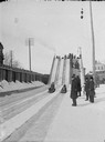
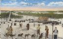
| Description: | St. Paul Ice Carnival, Toboggan Slide in Palace Grounds. View looking up track towards people grouped to the side of toboggan tracks, on stairs, and at the... |
| Date: | |
|---|---|
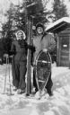
| Description: | Winter scene with Mary and Nelson Ross of Ross' Teal Lake Lodge. They are posing in the snow with skis and snowshoes. |
| Date: | |
|---|---|
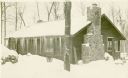
| Description: | Exterior view of a one-story wood cottage or cabin with a stone chimney and icicles handing off the roof. The ground and roof are covered in snow, and a pa... |
| Date: | |
|---|---|
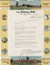
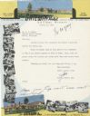
| Description: | Letterhead of the King's Gateway Hotel of Land O' Lakes, Wisconsin, with header and footer color views of the hotel and neighboring Gateway Inn. There are ... |
| Date: | |
|---|---|
| Description: | Letterhead of the King's Gateway Hotel in Land O' Lakes, Wisconsin, with header and footer views of the hotel and nearby Gateway Inn in color, and overlapp... |

| Date: | 1959 |
|---|---|
| Description: | This map of Lake Geneva has relief shown by contours and water depths shown by isolines. The map includes an index of schools, churches, public services, i... |

| Date: | 1966 |
|---|---|
| Description: | This colored road map shows automobile roads in Wisconsin as well as portions of nearby states. A map key indicates relative sizes of cities and towns. On ... |

| Date: | 1970 |
|---|---|
| Description: | This colored map displays a brief description of tourist attractions in the state, as well as a grid of state parks and recreational facilities. There is a... |

| Date: | 1966 |
|---|---|
| Description: | This colored road map shows automobile roads in Wisconsin as well as portions of nearby states. Information on the quality and type of any road shown (inte... |

| Date: | 1970 |
|---|---|
| Description: | This colored map displays detailed maps of Green Bay, Appleton, Racine, Milwaukee, Kenosha, and Duluth-Superior. At the top right is a map location list of... |

| Date: | 1971 |
|---|---|
| Description: | This colored map displays Wisconsin and bordering areas of Iowa, Minnesota, and Michigan. There is color-coding on the map to indicate National Forests, an... |

| Date: | 1973 |
|---|---|
| Description: | This colored map displays Wisconsin and bordering areas of Iowa, Minnesota, and Michigan. There is color-coding on the map to indicate National Forests, a... |

| Date: | 1975 |
|---|---|
| Description: | This colored road map of Wisconsin displays "Featured Points of Interest" and "Historical Points of Interest" in the state, including three color photograp... |

| Date: | 1973 |
|---|---|
| Description: | This map displays, in color, Wisconsin and bordering areas of Iowa, Minnesota, Illinois, and Michigan. At the bottom is a map key indicating road classifi... |

| Date: | 1976 |
|---|---|
| Description: | This color map displays Wisconsin and bordering areas of Iowa, Minnesota, Illinois, and Michigan. At the bottom is a map key indicating road classification... |

| Date: | 1976 |
|---|---|
| Description: | This colored map displays Wisconsin and portions of bordering states, including a detailed map of the Wisconsin Dells area. Surrounding the map are multipl... |

| Date: | 1977 |
|---|---|
| Description: | This colored map displays Wisconsin and portions of bordering states, including a detailed map of the Wisconsin Dells area. Surrounding the map are multipl... |
| Date: | 1949 |
|---|---|
| Description: | Text on front reads: "Wausau, Wisconsin, 'Winter Sports Capital of the Midwest.'" On reverse: "Renowned throughout the midwestern states as the center of w... |
If you didn't find the material you searched for, our Library Reference Staff can help.
Call our reference desk at 608-264-6535 or email us at: