 Filter: Categories of Wisconsin Historical Images
Filter: Subject of Winter sports
Filter: Subject of skis and skiing
Filter: Subject of transportation
Filter: Categories of Wisconsin Historical Images
Filter: Subject of Winter sports
Filter: Subject of skis and skiing
Filter: Subject of transportation
| Date: | 1930 |
|---|---|
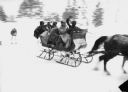
| Description: | Winter scene with sleigh carrying six well-bundled passengers pulled by two horses and pulling a skier behind in Eagle River. The trees are blurred. |

| Date: | |
|---|---|
| Description: | A family with skiing equipment stands in front of a lodge in winter. View features a large multi-story lodge with many windows and evergreen trees. |
| Date: | 01 26 1958 |
|---|---|
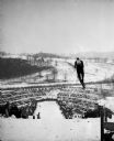
| Description: | Ski jumper Dale Severson of Eau Claire is shown (center right) flying and leaning high over the Tomahawk Ridge ski jump. Spectators and parked cars are in ... |
| Date: | |
|---|---|
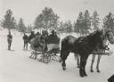
| Description: | Winter scene with six well-bundled passengers in a sleigh pulled by two horses and pulling two skiers behind. In the background are pine trees. |

| Date: | 1976 |
|---|---|
| Description: | Driver's side profile view of Scout II XLC for Olympic Games. Decal on side reads: "US SKI TEAM." |

| Date: | 1976 |
|---|---|
| Description: | Driver's side profile view of a red, white and blue Scout Traveler for the Olympic Games. Decal on side reads: "US SKI TEAM." |

| Date: | 1976 |
|---|---|
| Description: | Scout II vehicles parked in the snow. Decals on the side read: "US SKI TEAM." Men and women in ski clothing stand nearby. One woman is skiing down the hill... |

| Date: | 1976 |
|---|---|
| Description: | View up ski hill towards people standing near a Scout II in the snow. One man sits on a Quiet Flite Evinrude snowmobile near a man holding a pair of Head s... |

| Date: | 1976 |
|---|---|
| Description: | View from front of two people in a Scout driving through deep snow There are skis in the ski rack on the roof. Mountains are in the background. A woman is ... |

| Date: | 1966 |
|---|---|
| Description: | This colored road map shows automobile roads in Wisconsin as well as portions of nearby states. A map key indicates relative sizes of cities and towns. On ... |

| Date: | 1966 |
|---|---|
| Description: | This colored road map shows automobile roads in Wisconsin as well as portions of nearby states. Information on the quality and type of any road shown (inte... |

| Date: | 1970 |
|---|---|
| Description: | This colored map displays detailed maps of Green Bay, Appleton, Racine, Milwaukee, Kenosha, and Duluth-Superior. At the top right is a map location list of... |

| Date: | 1971 |
|---|---|
| Description: | This colored map displays Wisconsin and bordering areas of Iowa, Minnesota, and Michigan. There is color-coding on the map to indicate National Forests, an... |

| Date: | 1973 |
|---|---|
| Description: | This colored map displays Wisconsin and bordering areas of Iowa, Minnesota, and Michigan. There is color-coding on the map to indicate National Forests, a... |

| Date: | 1975 |
|---|---|
| Description: | This colored road map of Wisconsin displays "Featured Points of Interest" and "Historical Points of Interest" in the state, including three color photograp... |

| Date: | 1973 |
|---|---|
| Description: | This map displays, in color, Wisconsin and bordering areas of Iowa, Minnesota, Illinois, and Michigan. At the bottom is a map key indicating road classifi... |

| Date: | 1976 |
|---|---|
| Description: | This color map displays Wisconsin and bordering areas of Iowa, Minnesota, Illinois, and Michigan. At the bottom is a map key indicating road classification... |

| Date: | 1976 |
|---|---|
| Description: | This colored map displays Wisconsin and portions of bordering states, including a detailed map of the Wisconsin Dells area. Surrounding the map are multipl... |

| Date: | 1977 |
|---|---|
| Description: | This colored map displays Wisconsin and portions of bordering states, including a detailed map of the Wisconsin Dells area. Surrounding the map are multipl... |

| Date: | 1962 |
|---|---|
| Description: | This colored map represents "Tour #2" of a series of driving tours of the state published by the Sperry & Hutchinson Company, in order to "help you enjoy W... |
If you didn't find the material you searched for, our Library Reference Staff can help.
Call our reference desk at 608-264-6535 or email us at: