 Filter: Categories of Wisconsin Historical Images
Filter: Subject of Wisconsin
Filter: Creator Name of Unknown
Filter: Categories of Wisconsin Historical Images
Filter: Subject of Wisconsin
Filter: Creator Name of Unknown

| Date: | |
|---|---|
| Description: | This map is pen-and-ink on tracing paper with a mounted legend and shows the Kickapoo River, Indian mounds, the 1st Fort Crawford, an Indian Agency, the si... |

| Date: | |
|---|---|
| Description: | View across water of a Menominee man standing in a canoe in a marsh. He is holding a paddle in his hand. Behind him on the left is another canoe with three... |
| Date: | 1956 |
|---|---|
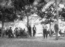
| Description: | Six Native American boys and teenagers take part in an archery competition. They are holding their bows and carrying arrows in a bag on their backs. Riley ... |

| Date: | |
|---|---|
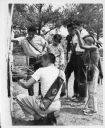
| Description: | Native American women and children wait in line by a bus to be tested for tuberculosis by the Wisconsin Anti-Tuberculosis Association. A sign points the wa... |
| Date: | |
|---|---|
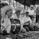
| Description: | Several Indian men kneel on a rug to play the moccasin game. One man is holding a drum and wearing a headdress (also called a war bonnet). |
| Date: | |
|---|---|
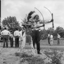
| Description: | Sam Carley Blowsnake and Jacob Lone Tree stand side by side, drawing back arrows in their bows. People are standing in the background. |

| Date: | |
|---|---|
| Description: | A night view of automobiles in the parking lot at the Stand Rock Amphitheater, where the Stand Rock Indian Ceremonial is performed. |

| Date: | |
|---|---|
| Description: | Cigar box cover with a head and shoulders portrait of Nelson Dewey. Beneath his portrait is a Native American headdress, a tomahawk, a stone club and a qui... |

| Date: | 1900 |
|---|---|
| Description: | This map shows landownership circa 1848 in the old Stockbridge Indian reservation on Lake Winnebago in Calumet County. It is oriented with north to the lef... |

| Date: | 1920 |
|---|---|
| Description: | A Native American trapper sits on his haunches in front of a building where various hides on stretchers have been hung to dry. The building is sided with s... |

| Date: | 1900 |
|---|---|
| Description: | This manuscript map shows outline of Fort Winnebago reserve land, Fort Winnebago, claim of A. Grignon, and Indian boundaries. The Fox River and Swan Lake a... |

| Date: | 1877 |
|---|---|
| Description: | Engraving of the Peck Cabin, after the painting by Mrs. E.E. Bailey. Caption at bottom reads: "First House in Madison. 1837." |

| Date: | 1925 |
|---|---|
| Description: | An unidentified Native American man posing while sitting on a corn planter pulled by a team of horses. |
| Date: | 1925 |
|---|---|
| Description: | A Caucasian man in a suit is standing at the center of a large arbor. Native American men and women are sitting or standing around him, while a Native Amer... |
| Date: | 1925 |
|---|---|
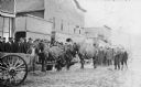
| Description: | View across unpaved road towards a Native American man wearing a plaid overcoat with two work horses. A crowd of men are watching from the elevated wooden ... |

| Date: | 1925 |
|---|---|
| Description: | Elevated view of a Native American man holding the lead of a horse as it is evaluated by another man, possibly Joseph Wojta, who is wearing a hat and long ... |

| Date: | 1930 |
|---|---|
| Description: | View across muddy ground towards a man holding a dairy cow by the halter, and on the left a boy holding the lead of a heifer. They are standing in front of... |

| Date: | 1920 |
|---|---|
| Description: | A handwritten sign identifies the "Shing-Wak Stock Farm, John B. Breselle (?) Prop., Dealer in Draft Horses." It also advertises "Green Mountain Seed Potat... |

| Date: | |
|---|---|
| Description: | Sixth plate ferrotype/tintype of three Woodland Native Americans. Full-length group portrait in front of a painted classical garden studio backdrop. They a... |

| Date: | 1720 |
|---|---|
| Description: | Map showing the course of the Mississippi River from the Gulf of Mexico up past Lake Superior into Canada. It shows the towns, Native American tribes and l... |
If you didn't find the material you searched for, our Library Reference Staff can help.
Call our reference desk at 608-264-6535 or email us at: