Filter: Categories of Wisconsin Historical Images
Filter: Subject of Wisconsin River (Wis.)
Filter: Subject of transportation
Filter: Categories of Wisconsin Historical Images
Filter: Subject of Wisconsin River (Wis.)
Filter: Subject of transportation

| Date: | 1883 |
|---|---|
| Description: | Bird's-eye map of Prairie du Sac, Wisconsin with an inset of Clifton. |

| Date: | 1883 |
|---|---|
| Description: | Bird's-eye map of Sauk City. |

| Date: | 1879 |
|---|---|
| Description: | This map is a bird's-eye view of Wausau, the County Seat of Marathon County. The map features an index of points of interest. |

| Date: | 05 02 1964 |
|---|---|
| Description: | Sitting on the school lawn, students draw Highway 51, Marathon Mill, Rib mountain and the Wisconsin River. |
| Date: | 1928 |
|---|---|
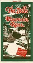
| Description: | "The Dells," a brochure issued by the Chicago, Milwaukee & St. Paul and Pacific Railroad to advertise the Wisconsin Dells, a destination only five hours fr... |
| Date: | |
|---|---|
| Description: | View down center of railroad bridge over the Wisconsin River near Lone Rock. |
| Date: | 1888 |
|---|---|
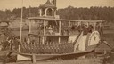
| Description: | Members of the Kilbourn Broom Brigade on the Alexander Mitchell steamboat in the Dells. Members of the group include: Minnie Smith, Mary Sterlie, Ru... |
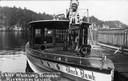
| Date: | |
|---|---|
| Description: | Chief Whirling Thunder, standing at the front of an excursion boat named "Black Hawk," which appears to be near the Wisconsin Dells. Caption reads: "Chief ... |
| Date: | 1935 |
|---|---|
| Description: | View of covered bridge above the Wisconsin River, 1 mile from Boscobel. |
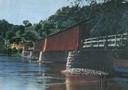
| Date: | 1930 |
|---|---|
| Description: | View of covered bridge, built in 1890, over the Wisconsin River with surrounding landscape. |
| Date: | 1933 |
|---|---|
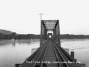
| Description: | Elevated view of a covered railroad bridge over a calm body of water, with bluffs in the background. |
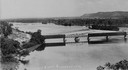
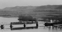
| Date: | |
|---|---|
| Description: | Elevated view of railroad bridge over the river. Part of the bridge is covered. Bluffs are in the background. |

| Date: | 1920 |
|---|---|
| Description: | Bridge over river from shoreline seen through trees in the spring or summer. Part of the bridge is covered. |
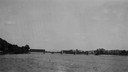
| Date: | 1920 |
|---|---|
| Description: | View across water towards the partially covered bridge. A wooded shoreline is along the left and right. |

| Date: | 1920 |
|---|---|
| Description: | Aerial view of the last covered bridge, which is no longer standing. |
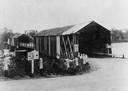
| Date: | 1900 |
|---|---|
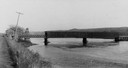
| Description: | View from road of a partially covered bridge. Industrial buildings are near the entrance to the bridge on the left. |
| Date: | |
|---|---|
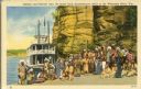
| Description: | Winnebago (Ho-Chunk) Indians posing in front of the steamboat Winnebago near the Stand Rock Amphitheater. This is where the Stand Rock Indian Ceremo... |
| Date: | 1910 |
|---|---|
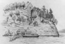
| Description: | Elevated view across water toward the Larks Hotel and ferry. Caption reads: "Larks Hotel, Wisconsin Dells." |

| Date: | 1878 |
|---|---|
| Description: | Kilbourn Bridge at the Wisconsin Dells, Wisconsin. A locomotive is pulling railroad cars over the bridge. |
If you didn't find the material you searched for, our Library Reference Staff can help.
Call our reference desk at 608-264-6535 or email us at: