 Filter: Categories of Wisconsin Historical Images
Filter: Subject of Wisconsin River (Wis.)
Filter: Subject of transportation
Filter: Year of 1900-1999
Filter: Categories of Wisconsin Historical Images
Filter: Subject of Wisconsin River (Wis.)
Filter: Subject of transportation
Filter: Year of 1900-1999

| Date: | 1936 |
|---|---|
| Description: | This map is red and black ink on tracing cloth and is oriented with north to the upper left. This hand-drawn map shows a central portion of the military ro... |
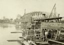
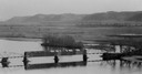
| Date: | 1910 |
|---|---|
| Description: | Construction gang at work on the Wisconsin River Bridge. |
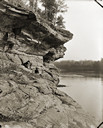
| Date: | 1900 |
|---|---|
| Description: | View along rockface shoreline towards a woman and two children sitting on Angel Rock. Along a cliff along the opposite shoreline are buildings and a bridge... |
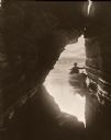
| Date: | 1906 |
|---|---|
| Description: | View out of Skylight Cave towards a man in a boat at the entrance to the cave. |
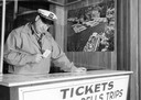
| Date: | 1950 |
|---|---|
| Description: | A man operating a ticket booth in the Wisconsin Dells. He is playing a card game, probably solitaire, on the counter. |
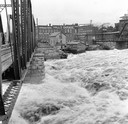
| Date: | 1916 |
|---|---|
| Description: | Water churns under a railroad bridge as the spring thaw swells the Wisconsin River. |

| Date: | 05 02 1964 |
|---|---|
| Description: | Sitting on the school lawn, students draw Highway 51, Marathon Mill, Rib mountain and the Wisconsin River. |
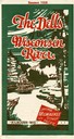
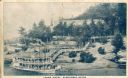
| Date: | 1928 |
|---|---|
| Description: | "The Dells," a brochure issued by the Chicago, Milwaukee & St. Paul and Pacific Railroad to advertise the Wisconsin Dells, a destination only five hours fr... |
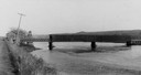
| Date: | 1935 |
|---|---|
| Description: | View of covered bridge above the Wisconsin River, 1 mile from Boscobel. |
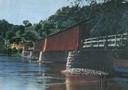
| Date: | 1930 |
|---|---|
| Description: | View of covered bridge, built in 1890, over the Wisconsin River with surrounding landscape. |
| Date: | 1933 |
|---|---|
| Description: | Elevated view of a covered railroad bridge over a calm body of water, with bluffs in the background. |

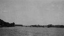
| Date: | 1920 |
|---|---|
| Description: | Bridge over river from shoreline seen through trees in the spring or summer. Part of the bridge is covered. |
| Date: | 1920 |
|---|---|
| Description: | View across water towards the partially covered bridge. A wooded shoreline is along the left and right. |

| Date: | 1920 |
|---|---|
| Description: | Aerial view of the last covered bridge, which is no longer standing. |
| Date: | 1900 |
|---|---|
| Description: | View from road of a partially covered bridge. Industrial buildings are near the entrance to the bridge on the left. |
| Date: | 1910 |
|---|---|
| Description: | Elevated view across water toward the Larks Hotel and ferry. Caption reads: "Larks Hotel, Wisconsin Dells." |
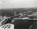
| Date: | 1955 |
|---|---|
| Description: | Aerial view of Wisconsin Dells. The wing of the airplane is in the left foreground. |
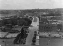
| Date: | 1928 |
|---|---|
| Description: | Elevated view of the main street with the Wisconsin River in the top left corner. The street just outside the Hall Garage Company is lined with cars. |
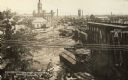
| Date: | 07 1912 |
|---|---|
| Description: | Elevated view across the Wisconsin River, showing the wreckage left by the disastrous flood of July 24, 1912. A power dam on the Wisconsin River above Waus... |
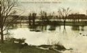
| Date: | 1909 |
|---|---|
| Description: | View from shoreline towards Stroller's Bridge. Caption reads: "Strollers Bridge and the Old Wisconse, Wausau, Wis." |
If you didn't find the material you searched for, our Library Reference Staff can help.
Call our reference desk at 608-264-6535 or email us at: