 Filter: Categories of Wisconsin Historical Images
Filter: Subject of Wisconsin River (Wis.)
Filter: Year of 1800-1899
Filter: Subject of cities and towns
Filter: Categories of Wisconsin Historical Images
Filter: Subject of Wisconsin River (Wis.)
Filter: Year of 1800-1899
Filter: Subject of cities and towns

| Date: | 1861 |
|---|---|
| Description: | Drawn the first year of the Civil War, this colored 1861 map of Dane County shows its towns, cities and lakes. It includes insets of the wards of Madison a... |

| Date: | 1891 |
|---|---|
| Description: | Bird's-eye map of Wausau, looking north with ninety-eight businesses, industries, churches, schools, and civic buildings identified in location key below i... |

| Date: | 1869 |
|---|---|
| Description: | Birds-eye drawing of Boscobel, Grant County, depicts street names and street layouts, houses, rivers and trees. A reference key at the bottom of the map sh... |

| Date: | 1868 |
|---|---|
| Description: | Bird's-eye map of Portage, with insets of the Court House and the Public School. |

| Date: | 1870 |
|---|---|
| Description: | Bird's-eye map of Prairie du Sac. |

| Date: | 1870 |
|---|---|
| Description: | Sauk City is the oldest incorporated village in Wisconsin (incorporated in 1854) and also has the oldest organized volunteer fire department in the state, ... |

| Date: | 1883 |
|---|---|
| Description: | Bird's-eye map of Prairie du Sac, Wisconsin with an inset of Clifton. |

| Date: | 1883 |
|---|---|
| Description: | Bird's-eye map of Sauk City. |

| Date: | 1879 |
|---|---|
| Description: | This map is a bird's-eye view of Wausau, the County Seat of Marathon County. The map features an index of points of interest. |

| Date: | 1878 |
|---|---|
| Description: | Kilbourn Bridge at the Wisconsin Dells, Wisconsin. A locomotive is pulling railroad cars over the bridge. |
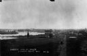
| Date: | 1890 |
|---|---|
| Description: | Elevated view looking up the Wisconsin River, with Wausau in the background. There are railroad cars on a bridge on the right. |
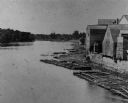
| Date: | 1898 |
|---|---|
| Description: | Elevated view of the Jackson Milling Company, the Green Bay railroad tracks, and the Wisconsin Central railroad tracks. Caption reads: "Birdseye View of Ri... |
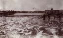
| Date: | 1880 |
|---|---|
| Description: | Elevated view of the Wisconsin River shoreline, showing lumber rafts "tied up over Sunday." |

| Date: | 1875 |
|---|---|
| Description: | View of the Sauk City bridge as seen from the Roxbury side. Two men are standing on the bridge on the far right, and buildings are behind the bridge on the... |
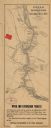
| Date: | 1891 |
|---|---|
| Description: | This late 19th century map of the Dells of the Wisconsin River shows the geographic features and topography of the area. Kilbourn City (present day Wiscons... |

| Date: | 1820 |
|---|---|
| Description: | A manuscript map of Prairie du Chien. |

| Date: | 1868 |
|---|---|
| Description: | Showing the counties, towns and railroads. Partly colored. Scale: 1 inch = 20 miles. |
If you didn't find the material you searched for, our Library Reference Staff can help.
Call our reference desk at 608-264-6535 or email us at:


