Filter: Categories of Wisconsin Historical Images
Filter: Subject of Wisconsin River (Wis.)
Filter: Year of 1800-1899
Filter: Categories of Wisconsin Historical Images
Filter: Subject of Wisconsin River (Wis.)
Filter: Year of 1800-1899

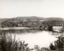
| Date: | 1875 |
|---|---|
| Description: | View of the Sauk City bridge as seen from the Roxbury side. Two men are standing on the bridge on the far right, and buildings are behind the bridge on the... |
| Date: | 1891 |
|---|---|
| Description: | This late 19th century map of the Dells of the Wisconsin River shows the geographic features and topography of the area. Kilbourn City (present day Wiscons... |

| Date: | 1820 |
|---|---|
| Description: | A manuscript map of Prairie du Chien. |

| Date: | 1840 |
|---|---|
| Description: | This map, one of a series made by Thomas Jefferson Cram of the U.S. Topographical Engineers from personal surveys, shows the portage connecting the Wiskons... |
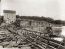
| Date: | 1895 |
|---|---|
| Description: | Munger's Mill and dam, with men standing on and around the dam. |

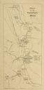
| Date: | 1868 |
|---|---|
| Description: | Showing the counties, towns and railroads. Partly colored. Scale: 1 inch = 20 miles. |
| Date: | 1850 |
|---|---|
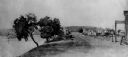
| Description: | Buildings along Wisconsin River. |

| Date: | 1829 |
|---|---|
| Description: | Photoprint of Crawford County lead district map. |
| Date: | 1886 |
|---|---|
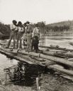
| Description: | Stereograph of five men standing on a log and a plank of wood while another man is chopping at the log with an axe. |
| Date: | 1886 |
|---|---|
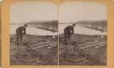
| Description: | Stereograph of a man on the end of the raft as he prepares to pass through the water's rough rapids. |
| Date: | 1886 |
|---|---|
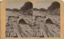
| Description: | Stereograph of a man as he rigs a rope around a log on a lumber raft. |

| Date: | 1849 |
|---|---|
| Description: | Pencil sketch of a cross-section of the Dells of the Wisconsin River. People are in a row boat in the center. Caption at bottom: "The Dells — Wisconsin Riv... |

| Date: | 1828 |
|---|---|
| Description: | Plat of the Private Claims at Prairie Du Chien. |

| Date: | 1878 |
|---|---|
| Description: | View from riverbank of the Chicago Milwaukee and St. Paul railroad locomotive no. 142 on the Kilbourn bridge. |

| Date: | 1894 |
|---|---|
| Description: | Panoramic view from shoreline of the Wisconsin River in the Wisconsin Dells as seen from the "Old Dell House." A canoe is visible on the shore on the far r... |

| Date: | 1894 |
|---|---|
| Description: | Panoramic view from shoreline of the Wisconsin River in the Wisconsin Dells. A sandy beach area is on the right, and rock formations are on both sides of t... |

| Date: | 1896 |
|---|---|
| Description: | Elevated panoramic view of a section of the Wisconsin Dells and the Wisconsin River visible from the "Sliding Rock." In the lower left hand corner the word... |
If you didn't find the material you searched for, our Library Reference Staff can help.
Call our reference desk at 608-264-6535 or email us at: