 Filter: Categories of Wisconsin Historical Images
Filter: Subject of Work
Filter: Year of 1900-1999
Filter: Year of 1930-1939
Filter: Subject of streams
Filter: Categories of Wisconsin Historical Images
Filter: Subject of Work
Filter: Year of 1900-1999
Filter: Year of 1930-1939
Filter: Subject of streams

| Date: | 1931 |
|---|---|
| Description: | A topographical map from the U.S. Army Corp of Engineers showing the topography and man-made features in the Camp Williams area of the towns of Orange and ... |

| Date: | 1935 |
|---|---|
| Description: | B.O. Webster, superintendent of fisheries, on the left in an overcoat, and an unidentified man carrying a pail and dipper, on the right, are walking along ... |
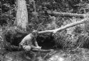
| Date: | 1935 |
|---|---|
| Description: | Arville is crouching at the edge of a stream. He has a camera case over his shoulder. Self-portrait. Caption on print reads: "A self-photo. Correspondent A... |
If you didn't find the material you searched for, our Library Reference Staff can help.
Call our reference desk at 608-264-6535 or email us at: