 Filter: Categories of Wisconsin Historical Images
Filter: Subject of Work
Filter: Year of 1900-1999
Filter: Year of 1960-1969
Filter: Subject of rivers
Filter: Categories of Wisconsin Historical Images
Filter: Subject of Work
Filter: Year of 1900-1999
Filter: Year of 1960-1969
Filter: Subject of rivers
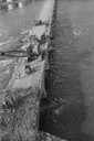
| Date: | 1960 |
|---|---|
| Description: | View looking down at people working on John Street Bridge during the razing. There is a crane on the bridge. |

| Date: | 08 05 1962 |
|---|---|
| Description: | Mr. Ortel, a United States Government lock-keeper at Appleton lock number one on the Fox River canal. Mr. Ortel is opening the sluice gates to allow water ... |

| Date: | 1968 |
|---|---|
| Description: | Two workmen in overalls and hardhats stand on a wooden walkway in the East River. The slick water-level walkway leads into a group of pilings and the back... |

| Date: | 1968 |
|---|---|
| Description: | A tugboat captain leans on a handrail and squints into the sun on a tug in the East River. Part of the wheelhouse is visible behind him. |

| Date: | 1968 |
|---|---|
| Description: | Journalist Robert Shaplen, facing the camera, at a bombed bridge over the Perfume River at Hue, where crowds of pedestrians and cyclists were attempting to... |
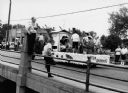
| Date: | 1964 |
|---|---|
| Description: | "Mayville photographer, Edgar G. Mueller, covers a parade in Theresa." |

| Date: | 1969 |
|---|---|
| Description: | This street map was given out by Mound City Bank and features a legend of points of interest and a street index. Streets are labeled as is the Roundtree Br... |

| Date: | 1960 |
|---|---|
| Description: | This street map was likely given out by Mound City Bank and features a legend of points of interest and a street index. Streets are labeled as is the Round... |

| Date: | 03 1965 |
|---|---|
| Description: | Keith Brigham is shown checking the U.S. Geological Survey stream gauging station located at the Yahara river locks on Lake Waubesa near McFarland. |

| Date: | 1965 |
|---|---|
| Description: | This series of 17 maps show boundaries and changes in city limits from 1846 to 1965. The base of all of the maps are the same, Milwaukee and suburbs. All m... |
If you didn't find the material you searched for, our Library Reference Staff can help.
Call our reference desk at 608-264-6535 or email us at: