 Filter: Categories of Wisconsin Historical Images
Filter: Subject of aids to navigation
Filter: Categories of Wisconsin Historical Images
Filter: Subject of aids to navigation

| Date: | 1780 |
|---|---|
| Description: | Map of Connecticut, Rhode Island, and Long Island. it shows the borders, cities, roads, islands, mountains, lakes and rivers. Navigational hazards along th... |

| Date: | 1733 |
|---|---|
| Description: | This map of North America shows settlements, rivers, lakes, Native American land, trade winds, and numerous topographical features such as forests and moun... |

| Date: | 1566 |
|---|---|
| Description: | Map showing the place names, rivers, and mountains of Europe, north-western Africa, the northern half of South America, and North America. Rhumb lines cros... |

| Date: | 1698 |
|---|---|
| Description: | A sea chart of Hudson's Bay, Greenland, and the Canadian Arctic. This map shows rhumb lines extending from various points including two compass roses. Coas... |

| Date: | 1786 |
|---|---|
| Description: | One half of a four sheet nautical chart, showing the coastlines of the north-west hemisphere. The interior lands are left bare, even of basic features such... |
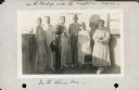
| Date: | 10 31 1930 |
|---|---|
| Description: | Alma Seipp Hay, second from right, and her husband, William Sherman Hay, third from left, join Commander C.W. Berndtson and other passengers on the bridge... |

| Date: | 1941 |
|---|---|
| Description: | Elevated view of Sturgeon Bay in 1900. Sturgeon Bay Bridge spans the bay and several boats are on the water. A lighthouse sits on a small island in the bay... |

| Date: | 1891 |
|---|---|
| Description: | Photograph of a painting by May Conniff Frost showing the tugboat Record of the Inman Line pulling a lake schooner through rough waters into Superio... |
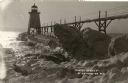
| Date: | |
|---|---|
| Description: | Postcard view along icy shoreline of the pier and lighthouse on Lake Michigan at Port Washington in winter. |

| Date: | 1890 |
|---|---|
| Description: | View from the shore of Kenosha's North Pier and lighthouse. Waves are breaking on the shore of Lake Michigan. |

| Date: | 1910 |
|---|---|
| Description: | Chart of Lake Michigan noting soundings near shore and across the lake between harbors. Also included are portions of Wisconsin, Michigan, Illinois, Indian... |
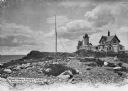
| Date: | |
|---|---|
| Description: | Eastern Point Lighthouse at "Mother Ann" and residence on rocky point, Gloucester, Massachusetts. Mother Ann is a rocky cliff at the far south end of Easte... |
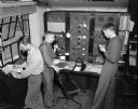
| Date: | 01 30 1947 |
|---|---|
| Description: | Three men working at the Civil Aeronautics Administration interstate communication station at Truax Field. From left to right are: Guy J. Blakely checking... |
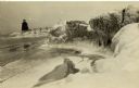
| Date: | |
|---|---|
| Description: | View of ice coated pier and lighthouse along the shore of Lake Michigan. Caption reads: "Winter Scene at Port Washington, Wis." |
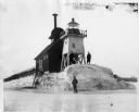
| Date: | |
|---|---|
| Description: | Three men pose standing on ice around North Pier lighthouse. In the background is the town along the shoreline. |
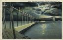
| Date: | 1927 |
|---|---|
| Description: | Hand-colored postcard view of a pier and lighthouse at night. The moon shines through clouds, and light shines in two directions from the beacon on top of ... |

| Date: | |
|---|---|
| Description: | Hand-colored postcard view of the Reef Lighthouse in Lake Michigan off the shore of Racine. A person is standing to the left of the lighthouse. Caption rea... |

| Date: | 1872 |
|---|---|
| Description: | Map of the Chippewa River, from the head of navigation at the city of Chippewa Falls, covering a distance of 16 miles above : showing the established impro... |
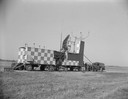
| Date: | |
|---|---|
| Description: | Radar equipment at Truax Field, formerly Madison Municipal Airport. |
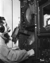
| Date: | |
|---|---|
| Description: | Man wearing microphone and headphones seated before a radar screen. |
If you didn't find the material you searched for, our Library Reference Staff can help.
Call our reference desk at 608-264-6535 or email us at: