 Filter: Categories of Wisconsin Historical Images
Filter: Subject of attractions
Filter: Categories of Wisconsin Historical Images
Filter: Subject of attractions

| Date: | 1950 |
|---|---|
| Description: | Text on front reads: "Wisconsin Dells, Wis." A model historical village with a guardhouse flying the American flag in the center, flanked by fences and mor... |
| Date: | 1950 |
|---|---|
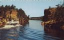
| Description: | Text on reverse reads: "Wisconsin Dells, Wis. Clipper 'Winnebago' at the Lower Jaws of the Dells showing Alligator Rock on the upper right hand corner." A ... |

| Date: | 1950 |
|---|---|
| Description: | Tourists on the "Commander", a Wisconsin Dells tour boat on the Wisconsin River. The shores are lined with rock formations and trees. |

| Date: | 09 01 1955 |
|---|---|
| Description: | Text on reverse reads: "The Original Dells Duck Tour. After descending the rock walled, fern covered trails, your Duck enters the beautiful Lower Dells of ... |

| Date: | 07 07 1970 |
|---|---|
| Description: | Text on reverse reads: "Riverside & Great Northern Railway. R. & G.N. Ry. afternoon local taking water south of Rockdale, at Wisconsin Dells, Wis." A minia... |

| Date: | 1957 |
|---|---|
| Description: | Text on reverse reads: "Wisconsin Deer Park, on Hw. 12-13, One-half Mile South of Wisconsin Dells, Wisconsin. Visitors Enjoy Feeding and Photographing the ... |

| Date: | 1950 |
|---|---|
| Description: | Text on reverse reads: "Land of Make Believe in the Center of Door County. Unique Museum. Largest Collection Anywhere. Old Marshall Field Window Mechanical... |

| Date: | 1950 |
|---|---|
| Description: | Text on reverse reads: "Land of Make Believe in the Center of Door County. Unique Museum. Largest Collection Anywhere. Old Marshall Field Window Mechanical... |
| Date: | 06 21 1958 |
|---|---|
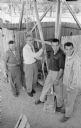
| Description: | Madison Park Superintendent James G. Marshall throwing the switch to turn on the new Vilas Park merry-go-round. Show (L-R) with Marshall are park crew memb... |

| Date: | 06 21 1958 |
|---|---|
| Description: | An unidentified boy enjoying his first ride on the new Vilas Park merry-go-round during the merry-go-round's grand opening. |

| Date: | 06 21 1958 |
|---|---|
| Description: | Professor Ray S. Owen, 5807 Winnequah Road (L), and Alderman Harrison L. Garner, Madison 13th Ward (R), enjoying a ride on the Vilas Park merry-go-round du... |

| Date: | 06 21 1958 |
|---|---|
| Description: | Attending the grand opening of the Vilas Park merry-go-round are, (L-R): Lawrence H. Fitzpatrick, Wisconsin State Journal managing editor; Robert C.... |
| Date: | 1953 |
|---|---|
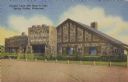
| Description: | Text on front reads: "Crystal Cave Gift Shop & Cafe, Spring Valley, Wisconsin". On reverse it reads: "Crystal Cave, Spring Valley, Wisconsin. Highway Wisco... |

| Date: | 05 |
|---|---|
| Description: | Young woman in a period dress standing at the front entrance of Villa Louis. |

| Date: | 1945 |
|---|---|
| Description: | Totem Pole Room at the Cave of the Mounds. Caption on back of print reads: "The Totem Pole Room is popular with visitors because of the rich coloring and r... |

| Date: | 06 15 1946 |
|---|---|
| Description: | Interior view of Eagle Cave, Richland County, featuring "Giant Stalagmites." Wisconsin's largest onyx cave. |

| Date: | 1976 |
|---|---|
| Description: | This color map displays Wisconsin and bordering areas of Iowa, Minnesota, Illinois, and Michigan. At the bottom is a map key indicating road classification... |

| Date: | 1973 |
|---|---|
| Description: | This map displays, in color, Wisconsin and bordering areas of Iowa, Minnesota, Illinois, and Michigan. At the bottom is a map key indicating road classifi... |

| Date: | 1980 |
|---|---|
| Description: | The general theme of this black and white map is "Discover and Enjoy Wisconsin." The front of the map depicts driving tours numbered 1 through 12; each to... |

| Date: | 1977 |
|---|---|
| Description: | This colored map displays Wisconsin and portions of bordering states, including a detailed map of the Wisconsin Dells area. Surrounding the map are multipl... |
If you didn't find the material you searched for, our Library Reference Staff can help.
Call our reference desk at 608-264-6535 or email us at: