Visit our other Wisconsin Historical Society websites!
 Filter: Categories of Wisconsin Historical Images
Filter: Subject of cemeteries
Filter: Categories of Wisconsin Historical Images
Filter: Subject of cemeteries

| Date: | 1891 |
|---|---|
| Description: | The index page of a Sanborn Map of Stevens Point. |

| Date: | 1914 |
|---|---|
| Description: | Pg. 44 West Half of Marion Township. Pg. 45 East Half of Marion Township. |
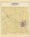
| Date: | 1889 |
|---|---|
| Description: | A plat map of Larrabee, township 25 north, range 14 east. |

| Date: | 1910 |
|---|---|
| Description: | A land ownership map of the township of Leroy. |

| Date: | |
|---|---|
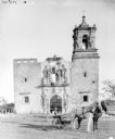
| Description: | View across field towards a long, stone building. There is a small shed behind the building on the left, and a fence is on the right. A person is walking n... |
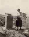
| Date: | 1926 |
|---|---|
| Description: | A woman holding flowers is standing between two graves, looking at the one on the left. Caption reads: "Wind River Indian Reservation (formerly the Shosho... |

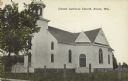
| Date: | 12 22 1906 |
|---|---|
| Description: | Text on front reads: "German Luth. Church near Whitehall, Wis." The church building on the right is surrounded by a farm, trees, fields and fences. |

| Date: | 06 26 1958 |
|---|---|
| Description: | A group of the Wisconsin Section of the National Daughters of the Grand Army of the Republic organization laying a memorial wreath to Civil War veterans at... |
| Date: | 1907 |
|---|---|
| Description: | Text on front reads: "United Lutheran Church. Strum, Wis." A clapboard church with gable decorations and a belfry. A fence surrounds the church with a ceme... |
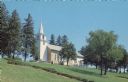
| Date: | 1963 |
|---|---|
| Description: | Text on the reverse reads: "East Wiota Lutheran Church, South Wayne, Wisconsin 53587. The Oldest Norwegian Lutheran Church in America still in use today. O... |

| Date: | 1944 |
|---|---|
| Description: | Portage County Map. Includes the towns of Eau Plaine, Dewey, Sharon, Alban, Carson, Hull, New Hope, Linwood, Stockton, Amherst, Plover, Grant, Buena Vista,... |

| Date: | 1900 |
|---|---|
| Description: | View across lawn towards a man using a mower in a cemetery. |

| Date: | 09 03 1926 |
|---|---|
| Description: | View across lawn, with shrubs and trees, towards a memorial, in stone, in the grass. A containers of flowers are in front of the memorial. |

| Date: | 1887 |
|---|---|
| Description: | A plat map of Waterford. Township 4, North Range 19, East of 4th Principal Meridian. References at bottom include school houses, houses, churches and cemet... |

| Date: | 1936 |
|---|---|
| Description: | This colored road map shows automobile roads in Wisconsin as well as portions of nearby states. Information on the quality and type of any given road (pave... |

| Date: | 07 25 1925 |
|---|---|
| Description: | View from side of road of a line of trucks on a road. There is a large piece of machinery in the background where men are working. In the background is a c... |

| Date: | 07 25 1925 |
|---|---|
| Description: | View from side of road looking down at a man using a dump truck for road construction. The truck is dumping material in front of a large machine. Men are w... |

| Date: | 1900 |
|---|---|
| Description: | Rear view of a man on a horse-drawn mower. In the background are the ruins of a large building, probably a church. |
| Date: | 1900 |
|---|---|
| Description: | Man posing on a horse-drawn mower in front of the ruins of a building surrounded by a fence. The building is probably a church as there are wreaths on grav... |
If you didn't find the material you searched for, our Library Reference Staff can help.
Call our reference desk at 608-264-6535 or email us at:
