Filter: Categories of Wisconsin Historical Images
Filter: Subject of education
Filter: County of Brown
Filter: Categories of Wisconsin Historical Images
Filter: Subject of education
Filter: County of Brown

| Date: | 1867 |
|---|---|
| Description: | Bird's-eye map of Green Bay and Fort Howard, Brown Co., depicts street names and street layouts, houses, trees, and the East River. A reference key at the ... |
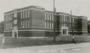
| Date: | 1910 |
|---|---|
| Description: | Exterior view from street of the high school. |

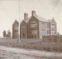
| Date: | 1890 |
|---|---|
| Description: | High school, built in 1857 and destroyed by fire in 1899. |

| Date: | 1906 |
|---|---|
| Description: | High school and its grounds. Caption reads: "High School, De Pere, Wis." |
| Date: | 1905 |
|---|---|
| Description: | Front view across unpaved road towards a high school, with a bicycle against a tall pole, and a fence in the foreground. |

| Date: | 1920 |
|---|---|
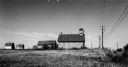
| Description: | "Miss Mahan's School" with a tree in front and a farmhouse next door. |
| Date: | 1906 |
|---|---|
| Description: | Exterior view of St. Joseph's academy, with school grounds. Caption reads: "'St. Joseph's Academy' Green Bay, Wis." |
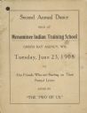
| Date: | 06 23 1908 |
|---|---|
| Description: | Menominee Training School dance card. |

| Date: | 01 15 1980 |
|---|---|
| Description: | "New Voters — It was "Swear In to Vote Day' at Pulaski High School. Students who have reached 18 were sworn in as voters during a ceremony at the school, a... |

| Date: | 1870 |
|---|---|
| Description: | This 1870 map of Brown County, Wisconsin, shows the township and range grid, towns, sections, cities, villages and post offices, land ownership, roads, rai... |

| Date: | 1896 |
|---|---|
| Description: | This map of Brown County, Wisconsin, from the late 19th century shows land claims along the Fox River, the township and range grid, towns, sections, cities... |

| Date: | 1903 |
|---|---|
| Description: | Map of Brown County, Wisconsin, shows the township and range grid, towns, sections, cities, villages and post offices, land owners and acreages, railroads,... |

| Date: | 1946 |
|---|---|
| Description: | This map shows streets, wards and precincts, parks, schools, and points of interest. The map is oriented with north to the upper left. The map includes a s... |

| Date: | 1963 |
|---|---|
| Description: | This blue line print shows as of March 1960 federal, state, county, and town roads, as well as railroads, schools, churches, town hall, parks, and Brown Co... |

| Date: | 1835 |
|---|---|
| Description: | Map shows the Fox River, lot and block numbers, private claims, streets, a public squares, a manual labour school, and Fort Howard. An inset map shows a pl... |

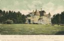
| Date: | |
|---|---|
| Description: | Colorized view of St. Joseph Academy, a Catholic High School. Caption reads: "St. Joseph Academy, Green Bay, Wis." |

| Date: | 1912 |
|---|---|
| Description: | Colored postcard of East Side High School, a stone building with large windows. Caption reads: "East Side High School, Green Bay, Wis." |

| Date: | |
|---|---|
| Description: | View of the business college on a neighborhood street corner. Caption reads: "Business College, Green Bay, Wis." |
If you didn't find the material you searched for, our Library Reference Staff can help.
Call our reference desk at 608-264-6535 or email us at: