 Filter: Categories of Wisconsin Historical Images
Filter: Subject of education
Filter: County of Douglas
Filter: Categories of Wisconsin Historical Images
Filter: Subject of education
Filter: County of Douglas
| Date: | 1905 |
|---|---|
| Description: | Caption reads: "State Normal School, Superior, Wis." Shrubs in front have been shaped into the letters: "NORMAL". |
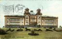
| Date: | 1930 |
|---|---|
| Description: | Exterior view across street towards a high school. Caption reads: "High School, Superior, Wis." |
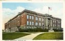
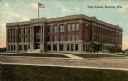
| Date: | 1915 |
|---|---|
| Description: | Exterior view of Central High School. Caption reads: "Central High School, Superior, Wis." |
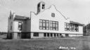
| Date: | 1937 |
|---|---|
| Description: | Large white building with facade details and bell tower. |

| Date: | 1889 |
|---|---|
| Description: | This 1889 map of Douglas County, Wisconsin, shows the township and range grid, towns, sections, cities and villages, roads, existing and proposed railroads... |

| Date: | 1899 |
|---|---|
| Description: | This 1899 map of Douglas County, Wisconsin, shows the township and range grid, towns, sections, cities, villages and railroad stations, mines, roads, railr... |

| Date: | 1914 |
|---|---|
| Description: | This 1914 map of Douglas County, Wisconsin, shows the township and range grid, towns, sections, cities and villages, roads, railroads, Indian trails, schoo... |

| Date: | 1919 |
|---|---|
| Description: | "Map showing the main travelled State and Federal Highways upon which the County Board proposes to expend $1,200,000 for permanent improvements, if you wil... |

| Date: | 1896 |
|---|---|
| Description: | This 1896 map of Douglas County, Wisconsin, shows the township and range grid, the towns of Superior, Brule, Gordon, and Nebagamain, sections, cities and v... |

| Date: | 11 26 1907 |
|---|---|
| Description: | Relief shown by hachures. Shows roads, railroads, schools, post offices, rivers, and lakes of Douglas County, and portions of Minnesota and Lake Superior. ... |

| Date: | 1930 |
|---|---|
| Description: | Shows county system of roads which are surfaced, well graded, common, or unimproved, town roads, state trunk highways, town and village boundaries, schools... |

| Date: | 1930 |
|---|---|
| Description: | Shows county system of roads which are surfaced, well graded, common, or unimproved, town roads, state trunk highways, town and village boundaries, schools... |
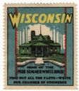
| Date: | 1928 |
|---|---|
| Description: | Stamp for Wisconsin created during or after President Calvin Coolidge's 1928 summer visit to Wisconsin. President Coolidge spent the summer fishing on the ... |

| Date: | 01 1856 |
|---|---|
| Description: | This map shows lots, lots appropriated for churches and schools, streets, parks, court house, and land to be appropriated for railroad depots. An inset map... |
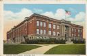
| Date: | 1915 |
|---|---|
| Description: | Text on front reads: "Central High School, Superior, Wis." The school was built in 1909 of brick in the Neoclassical style. In 1928, President Coolidge use... |
If you didn't find the material you searched for, our Library Reference Staff can help.
Call our reference desk at 608-264-6535 or email us at: