 Filter: Categories of Wisconsin Historical Images
Filter: Subject of education
Filter: County of Sheboygan
Filter: Categories of Wisconsin Historical Images
Filter: Subject of education
Filter: County of Sheboygan
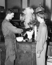
| Date: | 05 25 1951 |
|---|---|
| Description: | Chemistry experiment by two men being conducted with steam rising from equipment. |
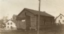
| Date: | 1910 |
|---|---|
| Description: | Exterior view of a school house, built in 1846. The sign on the building reads: "J. J. Koepsell Hdw. Co. House Furnishing Goods 1029 So 8 Str. Sheboygan, W... |
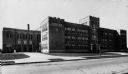
| Date: | |
|---|---|
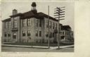
| Description: | View across street towards the South Side Junior High School in Sheboygan. |

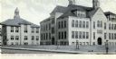
| Date: | 1920 |
|---|---|
| Description: | Exterior view of Sheboygan High School. Caption reads: "Sheboygan High School, Sheboygan, Wis." |
| Date: | 1910 |
|---|---|
| Description: | A view of the High School and Grade School. Caption reads: "FHigh School and the Grades, Plymouth, Wis." |
| Date: | 1905 |
|---|---|
| Description: | Exterior view of the High School. Caption reads: "High School, Plymouth, Wis." |
| Date: | 1932 |
|---|---|
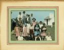
| Description: | Hand-colored photograph of students from Liberty school, a one-room school in Sheboygan County. The children in the back row are standing on the bumper of ... |
| Date: | 11 26 1930 |
|---|---|
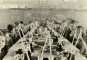
| Description: | Students and teacher seated at a long table loaded with food and drinks for a Thanksgiving meal. There are music and English lessons behind them on the cha... |

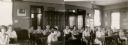
| Date: | 02 14 1956 |
|---|---|
| Description: | Group portrait of the Kohler "Blue Bombers" basketball team. |

| Date: | 1862 |
|---|---|
| Description: | This 1862 map of Sheboygan County, Wisconsin, shows land ownership and acreages, the township and range grid, towns, cities and villages, roads, railroads,... |

| Date: | 1906 |
|---|---|
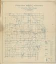
| Description: | This map of Sheboygan County, Wisconsin, from the early 20th century shows school districts and school locations in the county. Also shown are the township... |

| Date: | 1862 |
|---|---|
| Description: | Shows townships and sections, landownership and acreage, roads, railroads, churches, schools, and cemeteries. Inset maps: Plat of Hingham -- Plat of Casca... |
| Date: | 1911 |
|---|---|
| Description: | Shows routes, post offices, churches, houses, schools, roads, and collection boxes. "B. Oct. 11, 1911." Blue line print. "Sheboygan Co., Wis. 587." |
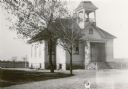
| Date: | 1931 |
|---|---|
| Description: | Broad stairs lead to the front door of the one-story, wood frame Rhine Center School, District No. 6. The school has a covered front porch, stone foundatio... |
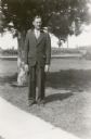
| Date: | 1931 |
|---|---|
| Description: | Kermit Schulz poses in front of a pine tree wearing a three piece suit. He is the teacher at Rhine Center School, District No. 6. |
| Date: | 1931 |
|---|---|
| Description: | Students at Rhine Center School pose at their desks for a group portrait. Most of the boys are wearing neckties. Twins Herbert and Norbert Hornbeck, 13, ar... |
| Date: | 1931 |
|---|---|
| Description: | Alvin Sebald, 14, a student at Rhine Center School, poses in front of a tree. He is wearing bib overalls and a necktie. There is a barn and other farm buil... |
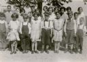
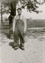
| Date: | 1931 |
|---|---|
| Description: | The students of the Rhine Center School, District No. 6, pose for their photograph in the schoolyard. The girls are wearing good dresses; the boys wear kni... |
If you didn't find the material you searched for, our Library Reference Staff can help.
Call our reference desk at 608-264-6535 or email us at:

