 Filter: Categories of Wisconsin Historical Images
Filter: Subject of indian reservations
Filter: Categories of Wisconsin Historical Images
Filter: Subject of indian reservations
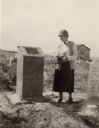
| Date: | 1926 |
|---|---|
| Description: | A woman holding flowers is standing between two graves, looking at the one on the left. Caption reads: "Wind River Indian Reservation (formerly the Shosho... |
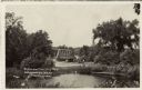
| Date: | |
|---|---|
| Description: | View over water towards a road leading to a bridge. A man is standing next to an automobile on the side of the road. |
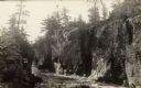
| Date: | |
|---|---|
| Description: | The Dells of the Wolf River in the Menominee Indian Reservation. |

| Date: | |
|---|---|
| Description: | Caption on back reads: "Neopit, Wis. Menominee Indian rocky outcroppings . . . winding falls . . . nature trail." |

| Date: | 1854 |
|---|---|
| Description: | A sketch of the public surveys of Wisconsin and territory of Minnesota. |

| Date: | 1973 |
|---|---|
| Description: | This colored map displays Wisconsin and bordering areas of Iowa, Minnesota, and Michigan. There is color-coding on the map to indicate National Forests, a... |

| Date: | 1971 |
|---|---|
| Description: | This colored map displays Wisconsin and bordering areas of Iowa, Minnesota, and Michigan. There is color-coding on the map to indicate National Forests, an... |

| Date: | 1972 |
|---|---|
| Description: | This colored map displays Wisconsin and bordering areas of Iowa, Minnesota, and Michigan. There is color-coding on the map to indicate National Forests, an... |
| Date: | 1935 |
|---|---|
| Description: | Two men and a woman are walking from a parked automobile toward the covered porch of the Oshkosh Trading Post, a low, log building on the Menominee Indian ... |
| Date: | 07 1936 |
|---|---|
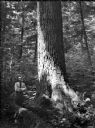
| Description: | Ray Weber standing next to a large white pine on a Menominee Indian reservation. |
| Date: | 07 1936 |
|---|---|
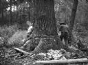
| Description: | Two men are working together to cut down a large white pine tree on a Menominee Indian reservation. |
| Date: | 07 1936 |
|---|---|
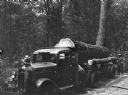
| Description: | A large, white pine tree is loaded on the back of a truck, ready to be hauled from a Menominee Indian reservation to the Wisconsin State Fair. |

| Date: | 1977 |
|---|---|
| Description: | Frances Decorah and her son Patrick at a Pow-wow in South Dakota. She is seated in a lawn chair and Patrick is napping on her lap. Frances is wearing stree... |

| Date: | 1790 |
|---|---|
| Description: | This map of the north eastern states shows roads, rivers, lakes, waterfalls, mountains, cities, forts, mills, the Oneida Reservation, and "New York Donatio... |

| Date: | 1840 |
|---|---|
| Description: | This map is pencil on paper and shows rivers, granite locations, and selected landmarks. Relief is shown by hachures. |

| Date: | 1914 |
|---|---|
| Description: | This map shows township grids, railroads, roads, and drainage. The area of the map covers northeastern Wisconsin and Menominee Indian reservation. Green Ba... |

| Date: | 1974 |
|---|---|
| Description: | This map draws content from a map originally created by George Featherstongaugh in 1840. The map shows streets, land ownership, the Brotherton Indian reser... |

| Date: | 1940 |
|---|---|
| Description: | This blue line print map traced from aerial survey mosaic shows reservation boundary, roads, trails, and railroads. Color manuscript annotations show triba... |
| Date: | 1933 |
|---|---|
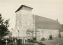
| Description: | The Catholic church of St. Francis Solanus is located on the Lac Courte Oreilles reservation. The church was built 1923-1924 of native pipestone under the ... |
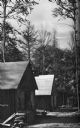
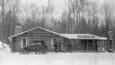
| Date: | 1936 |
|---|---|
| Description: | Exterior view of a logging camp on the Menominee Indian Reservation. The three buildings are surrounded by forest. |
If you didn't find the material you searched for, our Library Reference Staff can help.
Call our reference desk at 608-264-6535 or email us at: