 Filter: Categories of Wisconsin Historical Images
Filter: Subject of indians of north america
Filter: County of Ashland
Filter: Categories of Wisconsin Historical Images
Filter: Subject of indians of north america
Filter: County of Ashland

| Date: | 1917 |
|---|---|
| Description: | This 1917 map of Ashland County, Wisconsin, shows the township and range system, towns, sections, cities and villages, the Bad River Indian Reservation, ra... |

| Date: | 1925 |
|---|---|
| Description: | This 1925 map of Ashland County, Wisconsin, shows the township and range system, towns, sections, cities and villages, the Bad River Indian Reservation, ra... |

| Date: | 1890 |
|---|---|
| Description: | This map shows the Wisconsin Central Railroad land grant lands owned and for sale by the Soo Line in Ashland County, Wisconsin, as well as in portions of B... |

| Date: | 1886 |
|---|---|
| Description: | This map of Ashland County, Wisconsin, which at the time included part of present-day Iron County, also covers portions of Vilas County, Wisconsin, then pa... |

| Date: | 1890 |
|---|---|
| Description: | This 1890s map shows the Wisconsin Central Railroad land grant lands owned and for sale by the Soo Line in Ashland County, Wisconsin, as well as in the eas... |

| Date: | 1898 |
|---|---|
| Description: | This 1898 map of Ashland County, Wisconsin, shows the township and range grid, towns, sections, cities and villages, landownership, roads, railroads, swamp... |
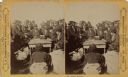
| Date: | 1852 |
|---|---|
| Description: | Group portrait of members of the La Pointe Band (now known as the Bad River La Pointe Band) of the Ojibwe Nation awaiting annuity payment at La Pointe. Non... |

| Date: | 1915 |
|---|---|
| Description: | This map shows school houses, churches, farms, and railroads. Chequamecon Bay and Bad River Indian Reservation are labeld. The map reads: "All lands shown ... |

| Date: | 1909 |
|---|---|
| Description: | This map shows vacant Wisconsin Central Ry. lands, settlers houses, lands sold by Wisconsin Central Ry., schools, churches, saw mills, and roads; also show... |

| Date: | 1910 |
|---|---|
| Description: | This map shows the locations of school houses, farms, roads, railroads, and Bad River Indian Reservation. Relief is shown by hachures. Yellow and red manus... |

| Date: | 1985 |
|---|---|
| Description: | This map shows mining, White River, Silver Creek, Bad River, Agogic Lake, Chequamegon Bay, smaller lakes, the Bad River Indian Reservation, and communities... |

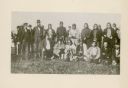
| Date: | 1915 |
|---|---|
| Description: | Elevated group portrait of men, women and children posing at the fairgrounds at Odanah. Most of the people are Native Americans, probably Ojibwe, with a nu... |

| Date: | 07 1936 |
|---|---|
| Description: | Wooden roof-like grave covers and fences mark the graves in a Madeline Island cemetery. There is also a wooden cross on the right. Originally named St. Jo... |
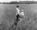
| Date: | 09 02 1966 |
|---|---|
| Description: | The caption on the reverse of this print explains: "Indians harvesting wild rice. Man poles rice boat while wife uses cedar ricing sticks and strips grain ... |

| Date: | 1866 |
|---|---|
| Description: | Stereograph of an Ojibwa woman sitting on an overturned canoe with a baby on her back wrapped in a blanket. A young child is sitting at her feet. They are ... |
| Date: | 1870 |
|---|---|
| Description: | Ojibwa Indians receiving annuity payment. Seated on the right is John W. Bell. Others are, left to right, Asaph Whittlesey, Agent Henry C. Gilbert, and Wil... |
If you didn't find the material you searched for, our Library Reference Staff can help.
Call our reference desk at 608-264-6535 or email us at: