Visit our other Wisconsin Historical Society websites!
 Filter: Categories of Wisconsin Historical Images
Filter: Subject of lakes
Filter: Categories of Wisconsin Historical Images
Filter: Subject of lakes

| Date: | |
|---|---|
| Description: | View across road towards a man mowing along a roadside. There is a lake or river in the background. |

| Date: | |
|---|---|
| Description: | View across lake towards a far shoreline, where a man is using a horse-drawn implement. |

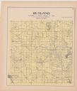
| Date: | 1922 |
|---|---|
| Description: | A plat map of the township of Delton near the Wisconsin River. |

| Date: | 1757 |
|---|---|
| Description: | The Canadian Lakes. Scale [ca. 1:6,500,000]. Paris: 1757. |
| Date: | 01 13 1961 |
|---|---|
| Description: | Ice boats on lake Monona during the International Skeeter Association regatta. |

| Date: | 01 13 1961 |
|---|---|
| Description: | Two ice-boaters compare notes during the International Skeeter Association regatta on lake Monona. Bill Perrigo (left) talks with Jack Ripp of the host Fou... |

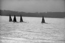
| Date: | 01 13 1961 |
|---|---|
| Description: | Iceboats on Lake Monona at the 18th annual International Skeeter Association regatta. |

| Date: | 1857 |
|---|---|
| Description: | Green Lake County plat map, T. 16 N, R. |

| Date: | 1857 |
|---|---|
| Description: | Green Lake County plat map, T. 15 N, R. 13 E. |

| Date: | 1857 |
|---|---|
| Description: | Green Lake County plat map, T. 14 N, R. 13 E. |

| Date: | 1857 |
|---|---|
| Description: | Green Lake County plat map, T. 16 N, R. 12 E. |

| Date: | 1857 |
|---|---|
| Description: | Green Lake County plat map, T. 14 N, R. 12 E. |
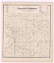
| Date: | 1873 |
|---|---|
| Description: | A plat map of the town of Pleasant Springs. |

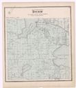
| Date: | 1899 |
|---|---|
| Description: | A plat map of the township of Christiana. |

| Date: | 1857 |
|---|---|
| Description: | Green Lake County Abstract plat map, T. 14 N, R. 11 E. |

| Date: | 1857 |
|---|---|
| Description: | Green Lake County plat map, T. 15 N., R. 12 E. |

| Date: | |
|---|---|
| Description: | Wisconsin Division of Tourism poster. View toward a woman sitting on a log at the shoreline of a lake or river with a bicycle laying on its side in the for... |
If you didn't find the material you searched for, our Library Reference Staff can help.
Call our reference desk at 608-264-6535 or email us at: