 Filter: Categories of Wisconsin Historical Images
Filter: Subject of mounds
Filter: Categories of Wisconsin Historical Images
Filter: Subject of mounds
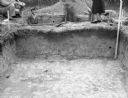
| Date: | 11 01 1947 |
|---|---|
| Description: | View across an excavation toward men and women standing above and behind it. Men are in another excavated hole behind it. Caption reads: "Excavation in cir... |

| Date: | 05 04 1915 |
|---|---|
| Description: | Caption reads: "An effigy of the water spirit type found at Clifton, Wis. The outline was whitewashed, the mound being carefully followed where it met the ... |

| Date: | 1969 |
|---|---|
| Description: | A map of Wisconsin from The Atlas of the Eight Counties of Forest, Florence, Iron, Langlade, Lincoln, Oneida, Price, Vilas. The map shows rivers and a vari... |

| Date: | 1845 |
|---|---|
| Description: | Map of Wisconsin, including lower western border with Iowa, southern border along Illinois, eastern shoreline of Lake Michigan, and northern area along Wis... |

| Date: | 05 23 1958 |
|---|---|
| Description: | Construction begins on Spring Harbor School, 1110 Spring Harbor Drive just north of University Avenue. The building was designed by Kaeser and McLeod Archi... |

| Date: | 1901 |
|---|---|
| Description: | Plat map showing land ownership of Township 21N Range 3W in Jackson County for 1901. Scale is 2 inches to 1 mile. |

| Date: | 1944 |
|---|---|
| Description: | Portage County Map. Includes the towns of Eau Plaine, Dewey, Sharon, Alban, Carson, Hull, New Hope, Linwood, Stockton, Amherst, Plover, Grant, Buena Vista,... |

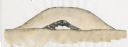
| Date: | 06 30 1939 |
|---|---|
| Description: | A drawing of a lizard-shaped Indian mound at Hudson Park. |

| Date: | 05 26 1906 |
|---|---|
| Description: | The Wisconsin Archeological Society attending the unveiling of the Cutler Indian mound marker at Cutler Park. Mrs. William H. Anderson, President (?) of th... |

| Date: | 01 25 2015 |
|---|---|
| Description: | Small patches of snow are covering the grass and dead leaves on an American Indian effigy mound. Trees are in the background. |
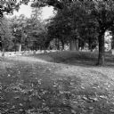
| Date: | 10 2013 |
|---|---|
| Description: | A grove of trees growing behind a line of gravestones at Forest Hill Cemetery, and what may be an effigy mound. Fallen leaves are on the grass. |

| Date: | 06 2008 |
|---|---|
| Description: | View looking east of a 1000-year-old Indian intaglio effigy in the shape of a panther. The effigy, which is on the north bank of the Rock River, is filled ... |

| Date: | 2009 |
|---|---|
| Description: | Watercolor of a Native American burial site. Generalized cross-section and stratigraphy of a typical Late Woodland effigy mound in Wisconsin. |

| Date: | 2009 |
|---|---|
| Description: | Watercolor of a Native American burial site. Reconstructed stratigraphy and cross-section representative of effigy mounds at the Nitschke Mound group. |

| Date: | 2009 |
|---|---|
| Description: | Watercolor of a Native American burial site. Reconstructed stratigraphy and cross-section representative of effigy mounds at the Kletzien Mound group. |
| Date: | 2009 |
|---|---|
| Description: | Watercolor of a Native American burial site. Reconstructed stratigraphy and cross-section representative of conical mounds at the Raisbeck Mound group. |

| Date: | 2009 |
|---|---|
| Description: | Watercolor of a Native American burial site. Reconstructed stratigraphy and cross-section representative of effigy mounds at the Kratz Creek Mound group. |

| Date: | |
|---|---|
| Description: | Ink and watercolor of prehistoric mounds near the mouth of Haigs Creek and the Scioto River. |

| Date: | |
|---|---|
| Description: | Map of prehistoric mounds near the Big Kanawha River. |
If you didn't find the material you searched for, our Library Reference Staff can help.
Call our reference desk at 608-264-6535 or email us at:
