 Filter: Categories of Wisconsin Historical Images
Filter: Subject of parks
Filter: Year of 2000-Present
Filter: Categories of Wisconsin Historical Images
Filter: Subject of parks
Filter: Year of 2000-Present

| Date: | 2007 |
|---|---|
| Description: | This map of Cedarbug is a bird's-eye map with 8 inset views and an index. The map is a print out of the original map dated 1892 held at the Cedarburg Cultu... |
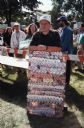
| Date: | 08 2000 |
|---|---|
| Description: | A man sells Gore-Lieberman buttons at Riverside Park. |

| Date: | 2004 |
|---|---|
| Description: | View from across street of a man holding Bush-Cheney '04 sign along intersection. A man next to him holds an illegible sign. |
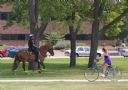
| Date: | 2008 |
|---|---|
| Description: | A female bike rider looks over at police officer riding a horse at Riverside Park. |
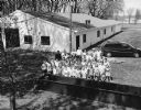
| Date: | 05 2000 |
|---|---|
| Description: | Group of students at Theresa Fireman's Park for Arbor Day activities. |

| Date: | 07 2001 |
|---|---|
| Description: | David Obey poses with Park Ranger Geoffrey Smith on the left and Martin Hanson on the right. They are standing on the beach with water and land in the back... |
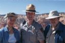
| Date: | 05 2005 |
|---|---|
| Description: | Joan Obey, Ranger Brent McGinn and Congressman David Obey at Bryce Canyon National Park. Canyon walls are in the far background. |

| Date: | 2008 |
|---|---|
| Description: | This double sided map shows roads, railroads, biking trails, civil townships, parks, wildlife refuges, town halls, and hospitals. The region map covers par... |

| Date: | 2000 |
|---|---|
| Description: | This map shows Wisconsin Public Service Corporation property, special regulation areas, public boat landings, roads, parks, and other recreation areas. Ins... |

| Date: | 09 2013 |
|---|---|
| Description: | View looking up at the facade of the synagogue known as Gates of Heaven. This synagogue has been converted over last century from a synagogue, to the Unita... |
| Date: | 11 2013 |
|---|---|
| Description: | View from shoreline with plants and tall grass towards a small stone bridge crossing over the lagoon at Vilas Park. |
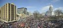
| Date: | 03 12 2011 |
|---|---|
| Description: | Elevated view of a large crowd gathered on the Capitol Square to protest the passage of the Act 10 bill and greet the return of the 14 Senate Democrats who... |

| Date: | 2004 |
|---|---|
| Description: | This map shows ATMs, houses of worship, hotels, parking ramps, public parking, union cab stands, bus stops, business district, parks and public areas, gove... |

| Date: | 2000 |
|---|---|
| Description: | This map shows the industrial area along the Menominee River and canals. Industrial buildings are shown in orange and labeled in red. Other areas are shown... |

| Date: | 2005 |
|---|---|
| Description: | This map shows dams and falls, areas of portage, canoe and kayak access, boat launches, parking, restrooms, picnic areas, dining, rapid water, parks, and b... |
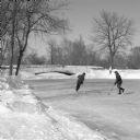
| Date: | 01 2014 |
|---|---|
| Description: | View from shoreline on a sunny day of snow-covered, frozen Monona Bay. People in the distance are standing or sitting near ice fishing holes and ice fishin... |
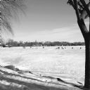
| Date: | 02 2014 |
|---|---|
| Description: | Two young men are playing hockey on the lagoon at Tenney Park. Snow is on the ground and the small foot bridge is in the background. |
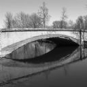
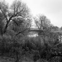
| Date: | 05 2014 |
|---|---|
| Description: | View across water towards the weathered footbridge spanning the Tenney Park lagoon near Marston Avenue. The word "Marston" is carved into the side of the b... |

| Date: | 06 2014 |
|---|---|
| Description: | Women and men wearing swim suits lying or sitting on the grass in James Madison Park. A man is resting against a tree in the foreground looking out over th... |
If you didn't find the material you searched for, our Library Reference Staff can help.
Call our reference desk at 608-264-6535 or email us at:
