Filter: Categories of Wisconsin Historical Images
Filter: Subject of recreation areas
Filter: County of Chippewa
Filter: Categories of Wisconsin Historical Images
Filter: Subject of recreation areas
Filter: County of Chippewa
| Date: | 1885 |
|---|---|
| Description: | Chippewa Falls with a park and river in the foreground. |
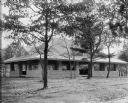
| Date: | 1926 |
|---|---|
| Description: | The tourist camp that the citizens of Chippewa Falls provided free for motorists passing through their community. |

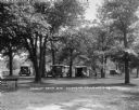
| Date: | 1905 |
|---|---|
| Description: | Clockwise from upper left images include: Cutters Point, Long Lake, Wis.; M.E. Church, New Auburn, Wis.; Farmers Store, New Auburn, Wis.; Public School, Ne... |
| Date: | 1910 |
|---|---|
| Description: | Margery Bish sitting on the wooden stairs at Irvine Park. Two men are standing further back on the tree-lined path. Irvine Park was established in 1906 on ... |
| Date: | |
|---|---|
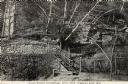
| Description: | A stone park shelter with a gabled roof at Irvine Park. Trees stand around the shelter. |
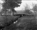
| Date: | |
|---|---|
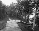
| Description: | A bridge across a small creek in Silver Springs Park. Some birch and pine trees are nearby. |
| Date: | |
|---|---|
| Description: | Rear view of a man and woman standing on a wooden bridge in a wooded area. |
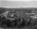
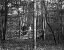
| Date: | |
|---|---|
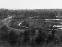
| Description: | Elevated view of park-like, lightly-wooded area with Duncan Creek running through it. A dirt road runs over a bridge to the left. The skyline of Chippewa F... |
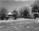
| Date: | 1900 |
|---|---|
| Description: | The inter-urban street car terminal station shelter at Irvine Park. A heavy snowfall covers the landscape. A stone wall gateway with lampposts and decorati... |
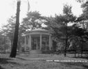
| Date: | 1926 |
|---|---|
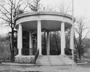
| Description: | A gazebo dedicated to solders and sailors in Irvine Park. A flagpole and benches are in front of the gazebo. |
| Date: | 1927 |
|---|---|
| Description: | A cylinder-shaped cement building with an open door in a rural area. In front of the building is a picnic table, and on the right an automobile is parked n... |
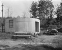
| Date: | 1924 |
|---|---|
| Description: | A swing set at a public park. There is a windmill in the background. |
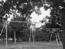
| Date: | 1908 |
|---|---|
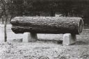
| Description: | Cut sample pine log mounted as an exhibit in Irvine Park. |

| Date: | 1951 |
|---|---|
| Description: | This map of Chippewa Falls shows the city of Chippewa River, city limits, roads, highways, fair grounds, and parks. |

| Date: | 1938 |
|---|---|
| Description: | This map shows plat of town, land ownership by name, city limits, section boundaries, wards, local roads, railroads, parks, fairgrounds, cemeteries, locati... |

| Date: | 1975 |
|---|---|
| Description: | This standard U.S.G.S. topographic map was annotated by civil engineer and railroad historian James P. Kaysen to show the location of existing and defunct ... |
| Date: | 1910 |
|---|---|
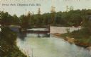
| Description: | Colorized view of a bridge crossing Duncan Creek in Irvine Park with trees and river bend in background. Caption reads: "Irvine Park, Chippewa Falls, Wis." |
| Date: | 1910 |
|---|---|
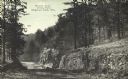
| Description: | Rock outcroppings with birch trees and a long staircase climbing a hill in Irvine Park. Caption reads: "A Cool Retreat and Springs, Irvine Park, Chippewa F... |
| Date: | 1910 |
|---|---|
| Description: | View down tree-lined "lovers' lane" on a hill along a stone wall and rock outcroppings in Irvine Park. Caption reads: "Lovers' Lane, Irvine Park, Chippewa ... |
If you didn't find the material you searched for, our Library Reference Staff can help.
Call our reference desk at 608-264-6535 or email us at: