Filter: Categories of Wisconsin Historical Images
Filter: Subject of transportation
Filter: Year of 1800-1899
Filter: Categories of Wisconsin Historical Images
Filter: Subject of transportation
Filter: Year of 1800-1899
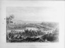
| Date: | 1884 |
|---|---|
| Description: | Lithographic engraving depicting two people on a bluff overlooking a river. Several canoes are present on the river. Caption reads: "'Valley of the Minneso... |
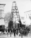
| Date: | 1885 |
|---|---|
| Description: | Elevated view of a crowd of people standing near an artesian well. Men wearing long coats and hats to protect them from the water are standing on and unde... |
| Date: | 1879 |
|---|---|
| Description: | Slightly elevated view across a river toward a large building with Greenwood Mills written on the side. The mill is reflected in the river in the foregroun... |

| Date: | 1875 |
|---|---|
| Description: | Elevated view of several buildings, with bridge and railroad tracks, and the Fox River. In the foreground on the right is the Commercial House, with three ... |

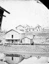
| Date: | 1870 |
|---|---|
| Description: | Elevated view of an unpaved main street, with the Village House across the street in the center background. Wooden buildings and wooden sidewalks are on bo... |

| Date: | 1852 |
|---|---|
| Description: | Illustrations of 5 different canoes. Caption reads: "Plate 9, opp. pg. 66. Vol. 1, Indian Tribes of the United States. ed. Francis S. Drake, 1884. A... |
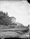
| Date: | 1890 |
|---|---|
| Description: | View across unpaved road towards a row of buildings on the other side. A fence and trees are on the left, and in front of the first building a group of men... |

| Date: | 1891 |
|---|---|
| Description: | Page 13 of a Sanborn map of Stevens Point. |

| Date: | 1891 |
|---|---|
| Description: | The index page of a Sanborn Map of Stevens Point. |
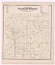
| Date: | 1873 |
|---|---|
| Description: | A plat map of the town of Pleasant Springs. |

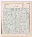
| Date: | 1899 |
|---|---|
| Description: | A plat map of the township of Christiana. |

| Date: | 1875 |
|---|---|
| Description: | One of a set of maps from G.K. Warren's 1876 Report on the transportation route along the Wisconsin and Fox rivers in the State of Wisconsin between the Mi... |

| Date: | 1857 |
|---|---|
| Description: | Green Lake County Abstract plat map, T. 14 N, R. 11 E. |
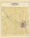
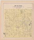
| Date: | 1889 |
|---|---|
| Description: | A plat map of Larrabee, township 25 north, range 14 east. |
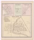
| Date: | 1873 |
|---|---|
| Description: | A page showing four plat maps: Stoughton, Clifton, Deanville, and Cross Plains. |
If you didn't find the material you searched for, our Library Reference Staff can help.
Call our reference desk at 608-264-6535 or email us at: