 Filter: Categories of Wisconsin Historical Images
Filter: Subject of wetlands
Filter: Categories of Wisconsin Historical Images
Filter: Subject of wetlands
| Date: | 1900 |
|---|---|
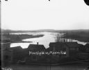
| Description: | Elevated view over the tops of buildings to the water beyond. A wooden sidewalk and fence runs along the street in the foreground. Caption on negative read... |
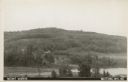
| Date: | 1907 |
|---|---|
| Description: | Text on front reads: "Mount Morris. Wautoma, Wis." A view of Mount Morris from above the shore of a lake or pond. A dwelling and perhaps a farm can be seen... |

| Date: | 1975 |
|---|---|
| Description: | View through snow-covered cattails after a winter snowfall towards a house on the left, and a barn and a silo on the right. |

| Date: | 1975 |
|---|---|
| Description: | A family of ducks swimming across a wetlands area. In the foreground reeds extending above the waterline. |
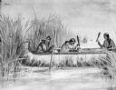
| Date: | |
|---|---|
| Description: | Drawing of three women in a canoe harvesting wild rice. |
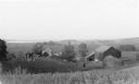
| Date: | 1935 |
|---|---|
| Description: | Elevated view from hill of chickens ranging near their coop behind a farmhouse and outbuildings on a tidy farm. There is a large barn on the right with two... |

| Date: | |
|---|---|
| Description: | View from grassy shoreline towards a wetlands area in the autumn. |
| Date: | |
|---|---|
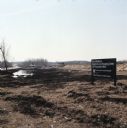
| Description: | View of a dredged wetland area near a road. A sign along the right reads: "New Middleton Neighborhood Shopping Center Site Preparation Work." |

| Date: | |
|---|---|
| Description: | Two men are surveying dried out wetlands. A farm is in the distance. |

| Date: | |
|---|---|
| Description: | A man wearing hip waders is standing in wetlands holding a collecting screen. He is collecting helgramites (a type of insect larva) to be used as bait for ... |

| Date: | 10 10 2014 |
|---|---|
| Description: | View down a wooden boardwalk with a viewing platform at the end. The view through the trees reveals the preserved wetlands within the Arboretum, called Gar... |
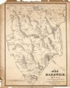
| Date: | 1833 |
|---|---|
| Description: | The map shows the distance of each dwelling-house from the common. The dwellings are listed by name of owner. |

| Date: | 1794 |
|---|---|
| Description: | Map of the United States east of the Mississippi River. It shows borders, treaty lines, forts, cities, towns, Native American land, mountains, swamps, lake... |

| Date: | 1780 |
|---|---|
| Description: | Detailed map of America east of the Louisiana region. It shows forts, cities, borders and boundary lines, Native American land, the post road, mountains, w... |

| Date: | 1720 |
|---|---|
| Description: | Detailed, ornate, and comprehensive map of America from the east coast to present day Texas. Numerous features appear throughout the map, including Native ... |

| Date: | 1784 |
|---|---|
| Description: | Detailed and ornate map of the newly formed United States. The borders of the southern states extend to the Mississippi River, though the states are only c... |

| Date: | |
|---|---|
| Description: | Watercolor painting of the Yahara River north of Lake Mendota. Trees are on the banks to the left with foliage throughout. A meadow is on the right. |

| Date: | |
|---|---|
| Description: | Watercolor painting of a bridge over a river, with pine trees on the right and a lone tree and foliage on the left. |

| Date: | |
|---|---|
| Description: | Watercolor painting of the Yahara River with trees and foliage on the banks. In the background trees line the far shore. |

| Date: | 1906 |
|---|---|
| Description: | Watercolor painting of the Yahara River at Lake Monona, with trees in the background and wetlands in the foreground. |
If you didn't find the material you searched for, our Library Reference Staff can help.
Call our reference desk at 608-264-6535 or email us at: