Visit our other Wisconsin Historical Society websites!
 Filter: Categories of Wisconsin Historical Images
Filter: Subject of wisconsin river (wis.)
Filter: Categories of Wisconsin Historical Images
Filter: Subject of wisconsin river (wis.)

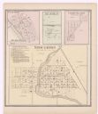
| Date: | 1922 |
|---|---|
| Description: | A plat map of the township of Delton near the Wisconsin River. |

| Date: | 1907 |
|---|---|
| Description: | View toward a waterfall from the river below. Rock faces rise on both sides, and trees are growing along the tops of the cliffs. Caption reads: "Lone Rock(... |

| Date: | 1907 |
|---|---|
| Description: | View upriver across rocks towards water falling over a rock under a small wooden bridge. The rockface of a bluff rises above the bridge in the background, ... |

| Date: | 1907 |
|---|---|
| Description: | Slightly elevated view of a river with choppy waves. The shoreline is rocky on the left and a man is sitting on one of the rocks. Further down the river on... |

| Date: | 1907 |
|---|---|
| Description: | Elevated view across river from the top of a cliff towards buildings along the the top of the cliffs on the opposite side. Far below a group of people are ... |

| Date: | 1907 |
|---|---|
| Description: | Elevated view of logs floating down the Wisconsin River, with rocky cliffs along the shoreline. A bridge and buildings are in the background, with a tree-c... |

| Date: | 1907 |
|---|---|
| Description: | View of the Wisconsin River, with a bridge in the distance. Buildings are on both sides of the bridge, and logs are piled below the bridge on the right. |

| Date: | 1907 |
|---|---|
| Description: | Elevated view from left side of a rocky shoreline of the Wisconsin River toward a bridge spanning it. Two men are standing on the rocks in front of the bri... |

| Date: | 1907 |
|---|---|
| Description: | View across the Wisconsin River towards buildings on the other side, with a bridge on the right supported by brick-covered supports. An excursion boat is f... |

| Date: | 1907 |
|---|---|
| Description: | Elevated view of the town of Lone Rock on the left, and the Wisconsin River nearby on the right. In the foreground below is a small bridge leading over a r... |

| Date: | 1891 |
|---|---|
| Description: | The index page of a Sanborn Map of Stevens Point. |

| Date: | 1875 |
|---|---|
| Description: | One of a set of maps from G.K. Warren's 1876 Report on the transportation route along the Wisconsin and Fox rivers in the State of Wisconsin between the Mi... |

| Date: | 1914 |
|---|---|
| Description: | Pg. 44 West Half of Marion Township. Pg. 45 East Half of Marion Township. |
| Date: | 1873 |
|---|---|
| Description: | A page showing four plat maps: Stoughton, Clifton, Deanville, and Cross Plains. |

| Date: | 1948 |
|---|---|
| Description: | Groups of people are on four or five boats traveling on the Wisconsin River, with a shoreline behind them on the left. In the distance is the opposite shor... |

| Date: | 1900 |
|---|---|
| Description: | A Sanborn fire insurance map of Sauk City created in 1900. |

| Date: | 1915 |
|---|---|
| Description: | A Sanborn fire insurance map of Sauk City created in 1915. |

| Date: | 1915 |
|---|---|
| Description: | A Sanborn fire insurance map of Sauk City created in 1915. |

| Date: | 1900 |
|---|---|
| Description: | A Sanborn fire insurance map of Sauk City created in 1900. |

| Date: | 1892 |
|---|---|
| Description: | A Sanborn fire insurance map of Sauk City which was drawn up in 1892. |
If you didn't find the material you searched for, our Library Reference Staff can help.
Call our reference desk at 608-264-6535 or email us at: