 Filter: Categories of Wisconsin Historical Images
Filter: GENRE of Map or Atlas
Filter: Year of 1800-1899
Filter: Year of 1880-1889
Filter: Categories of Wisconsin Historical Images
Filter: GENRE of Map or Atlas
Filter: Year of 1800-1899
Filter: Year of 1880-1889
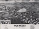
| Date: | 1882 |
|---|---|
| Description: | Bird's-eye map of Poynette, with one vignette. |

| Date: | 1881 |
|---|---|
| Description: | Bird's-eye map of Marinette, with insets. |

| Date: | 1886 |
|---|---|
| Description: | Bird's-eye view of Ashland, on the shores of Lake Superior, with insets of The Apostle Islands Chequamagon Bay & Ashland, and Distances from Ashland. |

| Date: | 1880 |
|---|---|
| Description: | Bird's-eye view of Jefferson on the Rock River. |

| Date: | 1886 |
|---|---|
| Description: | This map shows U.S. land offices, completed railroads, railroad land grant limits, lakes, rivers, and Indian reservations. Communities, lakes, and rivers a... |

| Date: | 1886 |
|---|---|
| Description: | Bird's-eye view of Bayfield, county seat of Bayfield County. On the lower left side is an inset for Bayfield and the Apostle Islands. |

| Date: | 1885 |
|---|---|
| Description: | Bird's-eye view of Watertown with indexed points of interest. |

| Date: | 1880 |
|---|---|
| Description: | Alma was platted and settled in 1855, on a narrow strip of land between high bluffs and the Mississippi River. Its location made it a popular shipping cent... |

| Date: | 1885 |
|---|---|
| Description: | Mining and lumbering provided the impetus for the development of northern Wisconsin and Ashland was ideally situated to become a leading city of the "new W... |

| Date: | 1886 |
|---|---|
| Description: | Bird's-eye map of Chippewa Falls, county seat of Chippewa Falls. |

| Date: | 1884 |
|---|---|
| Description: | Bird's-eye map of Delavan with inset of the State Institute for Deaf and Dumb. |

| Date: | 1886 |
|---|---|
| Description: | Bird's-eye map of Hurley with insets Mining at the Colby, Hurley in 1885, and North Front of Silver Street. |

| Date: | 1887 |
|---|---|
| Description: | Bird's-eye map of La Crosse, with six insets including residences, a store front, The John Gund Brewing Company, and C. & J. Michel Brewing Company. |

| Date: | 1885 |
|---|---|
| Description: | Bird's-eye map of Madison, State Capital of Wisconsin, County Seat of Dane County, with inset of the Wisconsin State Capitol. |

| Date: | 1889 |
|---|---|
| Description: | Illustration of the exterior of the Fuller Opera House, which is a detail from a bird's-eye view map of Madison. |

| Date: | 1882 |
|---|---|
| Description: | Bird's-eye views of various sections of Milwaukee. |

| Date: | 1885 |
|---|---|
| Description: | Bird's-eye map of Oconomowoc. |
If you didn't find the material you searched for, our Library Reference Staff can help.
Call our reference desk at 608-264-6535 or email us at:


