 Filter: Categories of Wisconsin Historical Images
Filter: GENRE of Postcard
Filter: Subject of aerial photographs
Filter: Subject of land
Filter: Categories of Wisconsin Historical Images
Filter: GENRE of Postcard
Filter: Subject of aerial photographs
Filter: Subject of land
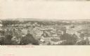
| Date: | 1905 |
|---|---|
| Description: | Caption reads: "Bird's-Eye View, Eau Claire Wis." |
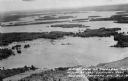
| Date: | 1955 |
|---|---|
| Description: | Aerial view of Treeland Pines resort on Lake Chippewa. Caption reads: "Air View of Bob Cammack's Treeland Pines Resort; Lake Chippewa, Hayward, Wis." |
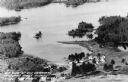
| Date: | 1955 |
|---|---|
| Description: | Aerial view of Treeland Pines Resort on Lake Chippewa. Caption reads: "Aerial View of Treeland Pines Resort on Lake Chippewa (The Flowage), Hayward, Wis." |

| Date: | 1960 |
|---|---|
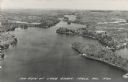
| Description: | Aerial view with docks in the foreground. Caption reads: "Superior, Wisconsin." |
| Date: | |
|---|---|
| Description: | Aerial view postcard of the Highlander Folk School grounds. |

| Date: | 04 12 1907 |
|---|---|
| Description: | Photographic postcard of an aerial view of town looking North. The Mississippi River is on the left. |
| Date: | |
|---|---|
| Description: | Photographic postcard of an aerial view of Lake Owen near Cable. Most of the lake is located within the Chequamegon National Forest. Caption reads: "Air Vi... |
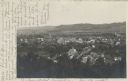
| Date: | 07 29 1909 |
|---|---|
| Description: | Aerial view of the downtown area, including a bridge spanning the Trempealeau River. Caption reads: "View of Arcadia, Wisconsin." |
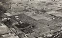
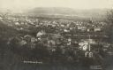
| Date: | 05 22 1906 |
|---|---|
| Description: | Aerial view of the city and rolling hills in the background. A bridge crossing the Trempealeau River is also visible. |

| Date: | 1950 |
|---|---|
| Description: | Aerial view of town, showing all of Lake Metonga in the background. Caption reads: "Greetings from Crandon, Wisconsin." |

| Date: | 1950 |
|---|---|
| Description: | Aerial view of the Island City surrounded by the waters of Beaver Dam Lake, and by a vacation and recreation area that includes some fifty lakes within a r... |

| Date: | 1910 |
|---|---|
| Description: | Aerial view along river toward Darlington. Caption reads: "Bird's-Eye View, Darlington, Wis." |
| Date: | 1950 |
|---|---|
| Description: | Aerial view of Sacred Heart Hospital. |
| Date: | 1950 |
|---|---|
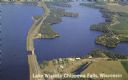
| Description: | Color photograph of an aerial view of Lake Wissota looking east on Highway 29. Many resorts are in the area. Lake Wissota is one of the largest man-made la... |
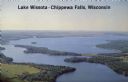
| Date: | 1950 |
|---|---|
| Description: | Aerial view, looking northwest, three miles east of Chippewa Falls, Wisconsin. Big Lake Wissota is seen across from Highway 29 in this color postcard, with... |

| Date: | 1950 |
|---|---|
| Description: | Aerial view of St. Bede's Priory and High School, including the surrounding country landscape. There is a highway behind the buildings. The Priory is the M... |

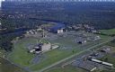
| Date: | 1930 |
|---|---|
| Description: | Aerial photographic postcard of Jack O'Lantern Lodge on Taylor Lake east of Eagle River on STH70, including the forest area surrounding the shoreline. Capt... |
| Date: | 1907 |
|---|---|
| Description: | Aerial view of Lake Hallie on the Chippewa river. |

| Date: | |
|---|---|
| Description: | Aerial view of harbor, with shipyards in the foreground and Superior in the background. Caption reads: "Aerial View of Harbor, Superior, Wisconsin." |
If you didn't find the material you searched for, our Library Reference Staff can help.
Call our reference desk at 608-264-6535 or email us at:
