 Filter: Categories of Wisconsin Historical Images
Filter: GENRE of Postcard
Filter: Subject of aerial photographs
Filter: Subject of roads
Filter: Categories of Wisconsin Historical Images
Filter: GENRE of Postcard
Filter: Subject of aerial photographs
Filter: Subject of roads
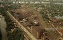
| Date: | |
|---|---|
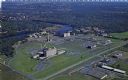
| Description: | Aerial view of the plant, with railroad tracks along both sides of the property. A river is on the left. Several cars are parked at the plant. There is an... |

| Date: | 1940 |
|---|---|
| Description: | Aerial view of the college. Several buildings make up the college, surrounded by paths, roads, fields and trees. Caption reads: "Mount Mary College." |
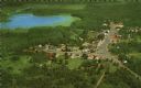
| Date: | 1959 |
|---|---|
| Description: | Color postcard of an aerial view of town. There is a lake in the background in the upper left. |

| Date: | |
|---|---|
| Description: | Color postcard of an aerial view of Cerami's Island View Hotel Motel Resort on the shore of Brown's Lake. |
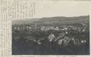
| Date: | 07 29 1909 |
|---|---|
| Description: | Aerial view of the downtown area, including a bridge spanning the Trempealeau River. Caption reads: "View of Arcadia, Wisconsin." |
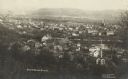
| Date: | 05 22 1906 |
|---|---|
| Description: | Aerial view of the city and rolling hills in the background. A bridge crossing the Trempealeau River is also visible. |
| Date: | 1967 |
|---|---|
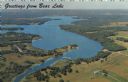
| Description: | Aerial view of Bear Lake, with surrounding forests and farms. Caption reads: "Greetings from Bear Lake." |

| Date: | 1950 |
|---|---|
| Description: | Aerial view of town, showing all of Lake Metonga in the background. Caption reads: "Greetings from Crandon, Wisconsin." |

| Date: | 1950 |
|---|---|
| Description: | Aerial view of the Island City surrounded by the waters of Beaver Dam Lake, and by a vacation and recreation area that includes some fifty lakes within a r... |

| Date: | 1950 |
|---|---|
| Description: | Aerial view of the camp, including a numbered index of the buildings. Used as an application form for a forestry workshop. Founded in 1944, located at 519 ... |

| Date: | 1960 |
|---|---|
| Description: | Aerial view of the Trees for Tomorrow Environmental Center, with buildings, grounds, roads, and the Eagle River. Founded in 1944. |
| Date: | 1950 |
|---|---|
| Description: | Aerial view of Sacred Heart Hospital. |
| Date: | 1950 |
|---|---|
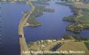
| Description: | Color photograph of an aerial view of Lake Wissota looking east on Highway 29. Many resorts are in the area. Lake Wissota is one of the largest man-made la... |

| Date: | 1950 |
|---|---|
| Description: | Aerial view of St. Bede's Priory and High School, including the surrounding country landscape. There is a highway behind the buildings. The Priory is the M... |

| Date: | 1930 |
|---|---|
| Description: | Aerial photographic postcard of Jack O'Lantern Lodge on Taylor Lake east of Eagle River on STH70, including the forest area surrounding the shoreline. Capt... |

| Date: | |
|---|---|
| Description: | Aerial view of Ephraim and Eagle Bay. A two-lane highway runs along the coastline. Caption reads: "Ephraim, Wisconsin." |

| Date: | 1934 |
|---|---|
| Description: | Aerial view of Long Lake and its islands. A road leads out to the biggest island. Caption reads: "Woodland Park, Long Lake, Haugen, Wis. Aerial Photo by N.... |

| Date: | |
|---|---|
| Description: | Kodak photographic postcard of an aerial view of a lakeside resort with a large, sandy beach. Caption reads: "Phil's Lake Nokomis Resort, Heafford Junction... |
| Date: | 1931 |
|---|---|
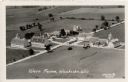
| Description: | Aerial view of a farm complex, including a farmhouse and several large buildings. Caption reads: "Wern Farms, Waukesha, Wis." |
If you didn't find the material you searched for, our Library Reference Staff can help.
Call our reference desk at 608-264-6535 or email us at:
