 Filter: Categories of Wisconsin Historical Images
Filter: GENRE of Postcard
Filter: Subject of hills
Filter: Subject of landscape
Filter: Categories of Wisconsin Historical Images
Filter: GENRE of Postcard
Filter: Subject of hills
Filter: Subject of landscape

| Date: | 1830 |
|---|---|
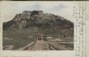
| Description: | Illustration of Fort Crawford. Caption reads: "Fort Crawford in 1830, Prairie Du Chien, Wis." |
| Date: | |
|---|---|
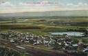
| Description: | Elevated view of Cochrane and the surrounding landscape. There are houses, railroad tracks, distant fields, a pond and some irrigation canals. Caption read... |
| Date: | 1905 |
|---|---|
| Description: | Elevated view of the town. Caption reads: "Part of Deerfield, Wis. -- viewed from the East". Handwritten note: "Dear Ella, Here comes the postal I am owing... |
| Date: | 1900 |
|---|---|
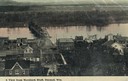
| Description: | Elevated view of Durand. A street in the foreground leads to a bridge that crosses the river. Caption reads: "A View from Morsbach Bluff, Durand, Wis." |

| Date: | 1905 |
|---|---|
| Description: | View across field and fence downhill towards the town of Fish Creek and the bay. Caption reads: "Greetings from Fish Creek, Wis." |
| Date: | |
|---|---|
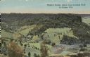
| Description: | Colorized view of Ebner's Coulee. Caption reads: "Ebner's Coulee, taken from Grandad Bluff, La Crosse, Wis." |
| Date: | |
|---|---|
| Description: | View from road towards farm buildings at the base of the bluff. A horse-drawn vehicle is on the rod. Caption reads: "Grand Dad's Bluff, La Crosse, Wis." |
| Date: | 1907 |
|---|---|
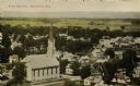
| Description: | Elevated view of church and town. Caption reads: "Bird's-Eye View, Mazomanie, Wis." |
| Date: | 1910 |
|---|---|
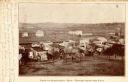
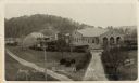
| Description: | Elevated view of Home store, Prairie Farm. Includes additional buildings. Caption reads: "Home Store Prairie Farm Wis." |
| Date: | 1907 |
|---|---|
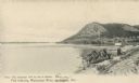
| Description: | Fishing implements on the shoreline of the Mississippi River, and a bluff in the background. Caption reads: "Fish Industry, Mississippi River, La Crosse, W... |
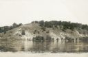
| Date: | 1907 |
|---|---|
| Description: | A view of the west bank of the Wisconsin River at Pounds Landing. This bluff is at the western end of the power dam which was constructed 1911-1914. Captio... |
| Date: | 1933 |
|---|---|
| Description: | Colorized postcard of Devil's Lake and bluffs seen through the trees. Some of the trees have autumn color. A roof and chimney are visible. The text at the ... |

| Date: | 12 29 1909 |
|---|---|
| Description: | Colorized postcard of the rock formation called the Devil's Doorway in Devil's Lake State Park. Trees are on the left and below. Bluffs, trees, sky and a r... |

| Date: | |
|---|---|
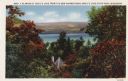
| Description: | Photographic postcard of the view to the west from the top of Blue Mounds, in Blue Mounds State Park. Handwritten is "Platteville Mounds, 45 miles" with an... |

| Date: | |
|---|---|
| Description: | Photographic postcard of the northwest view of Blue Mounds. Text below in a white box reads "N.W. View of Blue Mounds, Wis. Elevation 1760 ft." |

| Date: | |
|---|---|
| Description: | Photographic postcard of the view towards Madison from the top of Blue Mounds. Handwritten on the card is "State Capitol, 25 miles" with an arrow. Text bel... |
| Date: | |
|---|---|
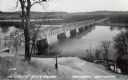
| Description: | Photographic postcard from hill looking down at the bridge over the Wisconsin River. A gas station is visible on the right. Text below reads: "Wisconsin Ri... |

| Date: | |
|---|---|
| Description: | Colorized, elevated view of the Pecatonica River with several of its many curves. Cows are grazing in the pasture in the foreground. The landscape is dotte... |

| Date: | |
|---|---|
| Description: | Elevated view from hill towards Cazenovia in winter. Caption reads: "Bird's-Eye View, Cazenovia, Wis." |
| Date: | 1910 |
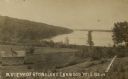
|---|---|
| Description: | View looking down hill towards Stone Lake, with wooded shoreline and a two-story log building in the foreground. Caption reads: "A View of Stone Lake, Cran... |
If you didn't find the material you searched for, our Library Reference Staff can help.
Call our reference desk at 608-264-6535 or email us at: