 Filter: Categories of Wisconsin Historical Images
Filter: GENRE of Postcard
Filter: Subject of streets
Filter: Subject of aerial photographs
Filter: Categories of Wisconsin Historical Images
Filter: GENRE of Postcard
Filter: Subject of streets
Filter: Subject of aerial photographs
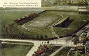
| Date: | 1908 |
|---|---|
| Description: | Aerial view of Camp Randall Stadium on the University of Wisconsin-Madison campus. Top image on Place File card. Caption reads: "Bird's-eye View, Camp Ra... |

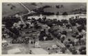
| Date: | 10 24 1946 |
|---|---|
| Description: | Photographic postcard of an aerial view of town. Text below reads: "Aerial View — Boscobel, Wis." |

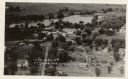
| Date: | 04 12 1907 |
|---|---|
| Description: | Photographic postcard of an aerial view of town looking North. The Mississippi River is on the left. |

| Date: | 1972 |
|---|---|
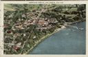
| Description: | Aerial view of commercial buildings and dwellings along the shore of Lake Michigan. Caption reads: "Baileys Harbor, Wisc." |

| Date: | 1911 |
|---|---|
| Description: | Reprint of a postcard of an aerial view from 1911, done for the Crivitz Centennial. Caption reads: "Crivitz, WI — 1911." |
| Date: | |
|---|---|
| Description: | Photographic postcard aerial view of Ettrick. A river is running through town. Dwellings and commercial buildings are surrounded by fields. |
| Date: | |
|---|---|
| Description: | Aerial view of Ettrick. A river and fields are in the background. There is a church in the foreground on the left, and on the main street are commercial bu... |
| Date: | 1956 |
|---|---|
| Description: | Caption reads: "Aerial View, Downtown Section, Green Bay, Wis." Text on reverse reads: "This aerial view shows the downtown district of the east side of ... |

| Date: | |
|---|---|
| Description: | Color postcard of downtown Green Bay and bridges spanning the Fox River. The Walnut Street Bridge is in the foreground. A 4-level parking garage is on the ... |

| Date: | |
|---|---|
| Description: | Colorized aerial view of central Janesville, with the Parker Pen building and Court House in the foreground. Caption reads: "Aeroplane View of Janesville, ... |

| Date: | |
|---|---|
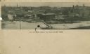
| Description: | Aerial view of brewery, with the Mississippi River in the background. Text on reverse reads: "Aerial view of G. Heilman Brewing Co., Inc., La Crosse, Wisc.... |
| Date: | 1929 |
|---|---|
| Description: | Aerial view of Lake Geneva (town) next to Lake Geneva (lake). Caption reads: "Aeroplane View of Lake Geneva, Wis." |

| Date: | 1923 |
|---|---|
| Description: | Aerial view of Capitol Square and surrounding area from East Washington Avenue. The old water tower in the center. Lake Monona is on the left; Lake Mendota... |

| Date: | 1980 |
|---|---|
| Description: | Aerial view of Capitol Square and the surrounding central isthmus. Lake Monona is on the right. |
| Date: | |
|---|---|
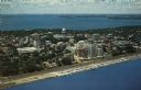
| Description: | Color aerial postcard of the Isthmus from over Lake Monona. John Nolen Drive is along the shoreline in the foreground. The Wisconsin State Capitol is in th... |
| Date: | |
|---|---|
| Description: | Aerial panoramic view of central Mayville over a frozen river. Caption reads: "All Roads Lead to Mayville, Wis." |

| Date: | 1940 |
|---|---|
| Description: | Text on front reads: "Birdseye, Business Center, Richland Center, Wis." An aerial view, looking north, of the town situated between tree covered hills. The... |

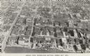
| Date: | 1922 |
|---|---|
| Description: | Text on front reads: "Aerial View of Sheboygan, Wis." The image shows the Sheboygan River from Lake Michigan to the Pennsylvania Avenue bridge. |
| Date: | 1971 |
|---|---|
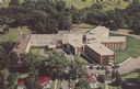
| Description: | Text on reverse reads: "An aerial view of the Skaalen Sunset Home and the New Addition completed Spring 1971, Stoughton, Wisconsin. The Home has 157 nursin... |
If you didn't find the material you searched for, our Library Reference Staff can help.
Call our reference desk at 608-264-6535 or email us at:
