Filter: Categories of Wisconsin Historical Images
Filter: State of Georgia
Filter: Categories of Wisconsin Historical Images
Filter: State of Georgia
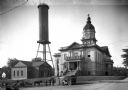
| Date: | 1910 |
|---|---|
| Description: | View of Athens City Hall, built in 1903-1904, featuring a central dome and clock tower. A water tower can be seen beyond the city jail to the left. |
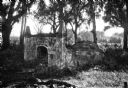
| Date: | |
|---|---|
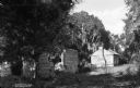
| Description: | View of a stone burial vault at Christ Church Cemetery, founded in 1808. |
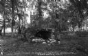
| Date: | |
|---|---|
| Description: | View into the ruins of a stone burial vault in Spanish Burial Grounds. |
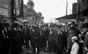
| Date: | 1920 |
|---|---|
| Description: | Men and children gather around a man giving a Christmas address. Coweta County Courthouse can be seen beyond the crowd, a Neoclassical Revival building des... |
| Date: | 1910 |
|---|---|
| Description: | View of the slave quarters at West Point Plantation. Copyright 1910 by Fleming & Bryant, Brunswick, GA. |
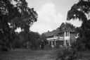
| Date: | |
|---|---|
| Description: | Exterior of the residence of Mr. J.A. Albright. The brick home can be seen amidst foliage. |
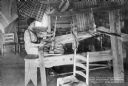
| Date: | |
|---|---|
| Description: | View of a woman weaving at a loom in the weaving room of the Berry School, which opened in 1902. Blankets are hanging near the ceiling. |

| Date: | |
|---|---|
| Description: | Interior of a company school operated by Gainesville Cotton Mills. Girls in the room work over large tubs and crates with cans and canning equipment. Boxe... |

| Date: | 1939 |
|---|---|
| Description: | A man standing on a large pile of coal uses a rake to load coal onto the bed of an International D-30 truck owned by Campbell Coal. The driver's side door ... |

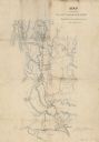
| Date: | 1864 |
|---|---|
| Description: | This map of the Atlanta area shows entrenchments, relief by hachures, vegetation, drainage, roads, railroads, towns, and the names of a few residents in th... |
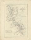
| Date: | 1864 |
|---|---|
| Description: | This map of northwestern Georgia shows dates and troop positions between Chattanooga, Tennessee, and Jonesboro, Georgia, May-September, 1864. Wisconsin uni... |
| Date: | 1864 |
|---|---|
| Description: | This map illustrates the route taken by the 3rd Division, 20th Corps, Army of the Cumberland under the command of Daniel Butterfield from the Snake Creek G... |

| Date: | 1865 |
|---|---|
| Description: | Detailed map of the southeastern United States showing fortifications, "movements of Genl. J.H. Wilson's Cavalry Corps," "pursuit of Hood" and the lines of... |

| Date: | 1865 |
|---|---|
| Description: | This pen and ink map sketches the route taken by General Sherman's troops from Atlanta, Georgia, to Savannah, Georgia. Railroads, rivers, and towns are lab... |

| Date: | |
|---|---|
| Description: | This detailed map shows fortifications, headquarters, location and dates of battles, street outline of Atlanta, roads, railroads, vegetation, drainage, rel... |

| Date: | 06 1962 |
|---|---|
| Description: | Jim Brosnahan instructs a class of International Harvester salesmen on the company farm at Tifton. International Harvester offered classes on the farm in o... |

| Date: | 1962 |
|---|---|
| Description: | Elevated view of International Harvester employees using the company's tractors and plows to work in a field on a company farm in Tifton. International Har... |

| Date: | 1962 |
|---|---|
| Description: | International Harvester salesmen gather at a table to share a meal at the company farm at Tifton. International Harvester offered classes on the farm in or... |

| Date: | 1962 |
|---|---|
| Description: | Instructor Jim Brosnahan (left, with foot on plow) gathers around a Kewaunee plow with International Harvester employees to study it at an International Ha... |
If you didn't find the material you searched for, our Library Reference Staff can help.
Call our reference desk at 608-264-6535 or email us at: