 Filter: Categories of Wisconsin Historical Images
Filter: State of Louisiana
Filter: Subject of land
Filter: Categories of Wisconsin Historical Images
Filter: State of Louisiana
Filter: Subject of land

| Date: | 1864 |
|---|---|
| Description: | This map shows pictorially a section of bracketdam, section of tree dam, and crib of stone. This map was prepared by order of General Joseph Bailey and is ... |
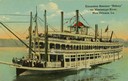
| Date: | |
|---|---|
| Description: | The sternwheel excursion, Sidney, on the Mississippi River at New Orleans. All three decks are full of passengers. Later named "Washington." |
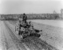
| Date: | 1943 |
|---|---|
| Description: | The caption for this photograph states that this Farmall MV tractor is "shown at work on the 2800-acre Triangle Farm near McCall, Louisiana, some 1800 acre... |
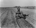
| Date: | 1943 |
|---|---|
| Description: | The caption for this photograph states that this Farmall MV tractor is "shown at work on the 2800-acre Triangle Farm near McCall, Louisiana, some 1800 acre... |

| Date: | 1943 |
|---|---|
| Description: | The caption for this photograph states that this Farmall MV tractor is "shown at work on the 2800-acre Triangle Farm near McCall, Louisiana, some 1800 acre... |

| Date: | 1943 |
|---|---|
| Description: | The caption for this photograph states that this Farmall MV tractor is "shown at work on the 2800-acre Triangle Farm near McCall, Louisiana, some 1800 acre... |

| Date: | 1943 |
|---|---|
| Description: | The caption for this photograph states that this Farmall MV tractor is "shown at work on the 2800-acre Triangle Farm near McCall, Louisiana, some 1800 acre... |

| Date: | 1943 |
|---|---|
| Description: | The caption states the "Farmall MV shown is owned by C.R. Tschirn of Donaldsville, Louisiana, who operates a 350-acre farm, 225 acres of which were in suga... |

| Date: | 1943 |
|---|---|
| Description: | The caption to this photograph indicates that Edward Aucoin of Belle Alliance, Louisiana, is operating a Farmall AV. |

| Date: | |
|---|---|
| Description: | View looking down hill toward the sawmill and logs floating in the pond. Company outbuildings are on the left, with a smokestack and silo. A water tower is... |

| Date: | |
|---|---|
| Description: | View from across the water of Bogue Falaya Landing and Boat House. Published by C.C. Champagne & Co. |
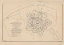
| Date: | 1862 |
|---|---|
| Description: | This detailed plan of Fort Jackson, in Plaquemines Parish, Louisiana, indicates the damage inflicted by the April, 1862, bombardment of the fort by Union f... |

| Date: | 1761 |
|---|---|
| Description: | Map covering southern Louisiana from Lake Ponchetrain to the Golf of Mexico and from Woods Bay in the west to the islands just east of Bay St. Louis. It sh... |

| Date: | 1759 |
|---|---|
| Description: | Map of New Orleans at the start of the French & Indian War, including two inset maps entitled "The Course of the Mississipi River from Bayagoulas to the Se... |

| Date: | 1769 |
|---|---|
| Description: | Map of New Orleans at the start of the French & Indian War, including two inset maps of the Mississippi River Delta and Fort la Balise. It shows streets, r... |

| Date: | 1761 |
|---|---|
| Description: | Map of New Orleans with north oriented towards the upper right corner. It shows the land around the city, the Mississippi River, anchorages, roads leading ... |

| Date: | 1950 |
|---|---|
| Description: | Subject: "UD-18A — Irrigation." Where Taken: "SW." Information with photograph reads: "Owned by Delta Securities Co., Inc., Raceland, La. Used with Worthin... |
If you didn't find the material you searched for, our Library Reference Staff can help.
Call our reference desk at 608-264-6535 or email us at: