 Filter: Categories of Wisconsin Historical Images
Filter: State of Louisiana
Filter: Subject of mississippi river
Filter: Categories of Wisconsin Historical Images
Filter: State of Louisiana
Filter: Subject of mississippi river
| Date: | |
|---|---|
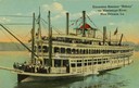
| Description: | The sternwheel excursion, Sidney, on the Mississippi River at New Orleans. All three decks are full of passengers. Later named "Washington." |
| Date: | |
|---|---|
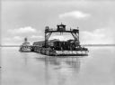
| Description: | View across water toward a railroad train and locomotive on a ferry going across the Mississippi River near New Orleans. |
| Date: | |
|---|---|
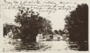
| Description: | Hives on top of a shed in a flood. From Mr. J.D. Shields, Natchez, Mississippi. A part of his Louisiana apiary placed on a shed to prevent their being swep... |
| Date: | |
|---|---|
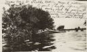
| Description: | View across water of beehives on top of a shed in a flood. Writing on photograph: "From Mr. J.D. Shields, Natchez, Mississippi. A picture of part of his Lo... |

| Date: | 1761 |
|---|---|
| Description: | Map covering southern Louisiana from Lake Ponchetrain to the Golf of Mexico and from Woods Bay in the west to the islands just east of Bay St. Louis. It sh... |

| Date: | 1759 |
|---|---|
| Description: | Map of New Orleans at the start of the French & Indian War, including two inset maps entitled "The Course of the Mississipi River from Bayagoulas to the Se... |

| Date: | 1769 |
|---|---|
| Description: | Map of New Orleans at the start of the French & Indian War, including two inset maps of the Mississippi River Delta and Fort la Balise. It shows streets, r... |

| Date: | 1761 |
|---|---|
| Description: | Map of New Orleans with north oriented towards the upper right corner. It shows the land around the city, the Mississippi River, anchorages, roads leading ... |
If you didn't find the material you searched for, our Library Reference Staff can help.
Call our reference desk at 608-264-6535 or email us at: