 Filter: Categories of Wisconsin Historical Images
Filter: State of Massachusetts
Filter: Subject of transportation
Filter: Subject of intellectual life
Filter: Categories of Wisconsin Historical Images
Filter: State of Massachusetts
Filter: Subject of transportation
Filter: Subject of intellectual life

| Date: | 1965 |
|---|---|
| Description: | Man delivering a stack of Boston Herald newspapers from an International C-series truck parked along the curb in the downtown Boston area at Boston Common.... |
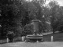
| Date: | 1895 |
|---|---|
| Description: | View of a statue and fountain in a grassy park depicting a boy selling a newspaper. Installed in 1895 and funded by Colonel William L. Brown, the statue c... |
| Date: | |
|---|---|
| Description: | Bird's-eye drawing of town, with an inset at bottom center of the Soldiers' Monument. Caption reads, "Bird's-eye view of Village of Barre, Mass." |

| Date: | 1928 |
|---|---|
| Description: | Holiday card depicting a view of the front of an automobile with a couple inside driving down a snow-covered road at night. Two crystals are glued to the h... |

| Date: | |
|---|---|
| Description: | View of North Adams Public Library from a street intersection. The building was designed in the Victorian style and renovated for library use in 1897 by ar... |

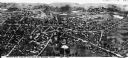
| Date: | |
|---|---|
| Description: | Aerial view of Plymouth. Published by McLaughlin Aerial Surveys. |
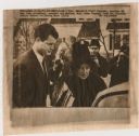
| Date: | 11 24 1963 |
|---|---|
| Description: | Original UPI Wirephoto transmission. Caption reads: "Sen. Edward M. "Ted" Kennedy, brother of the late president, escorts his mother, Mrs. Rose Kennedy fro... |

| Date: | 1775 |
|---|---|
| Description: | Map of Boston and surrounding regions, from Massachusetts Bay to the Connecticut River, and including part of southern New Hampshire. It shows the colonies... |

| Date: | 1780 |
|---|---|
| Description: | Map of eastern Massachusetts, Rhode Island, eastern Connecticut, and small portions of New Hampshire and Vermont. It shows the boundaries, counties, citie... |

| Date: | 1795 |
|---|---|
| Description: | Map of Massachusetts showing counties, cities, roads, islands (including Nantucket and Martha's Vineyard), mountains, hills, lakes, and rivers. Two small e... |

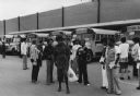
| Date: | 1975 |
|---|---|
| Description: | Students from Columbia Point waiting outdoors to be bused to South Boston High School. Most of the students are walking, and a few are clowning for the cam... |
| Date: | 1975 |
|---|---|
| Description: | Students from Columbia Point waiting to be bused to South Boston High School. Most of the students are standing in groups, talking. School buses are parked... |
If you didn't find the material you searched for, our Library Reference Staff can help.
Call our reference desk at 608-264-6535 or email us at: