 Filter: Categories of Wisconsin Historical Images
Filter: State of Michigan
Filter: Subject of canals
Filter: Categories of Wisconsin Historical Images
Filter: State of Michigan
Filter: Subject of canals
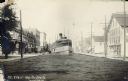
| Date: | 11 17 1909 |
|---|---|
| Description: | A riverboat travels down a narrow canal. Storefronts, sidewalks and telephone poles line either side of the canal. Caption reads: "St. Clair Up-to-Date." ... |

| Date: | 1925 |
|---|---|
| Description: | This map shows lakes, islands and bays. The Upper Peninsula of Michigan and Ontario are labeled. Three inset maps include the Upper end of St. Marys River ... |

| Date: | 1851 |
|---|---|
| Description: | This map shows townships, villages, Indian villages, railroads, roads, mills, prairies, swamps, and canals. An inset map shows a plat of the copper distric... |
If you didn't find the material you searched for, our Library Reference Staff can help.
Call our reference desk at 608-264-6535 or email us at: