 Filter: Categories of Wisconsin Historical Images
Filter: State of Michigan
Filter: Subject of islands
Filter: Categories of Wisconsin Historical Images
Filter: State of Michigan
Filter: Subject of islands
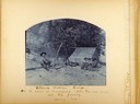
| Date: | 1889 |
|---|---|
| Description: | Beach fishing camp showing several people around a fire drying fish with a tent in the background. Captioned: Ottawa Fishing Camp -- On the Island at Fran... |
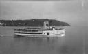
| Date: | |
|---|---|
| Description: | View of the steamer ship "Islander" leaving Mackinac Island. Signs painted on the ship reads=: "Islander," "Arnold Line" and "St. Ignace Mackinac Island" (... |

| Date: | |
|---|---|
| Description: | Ruins of a Mormon cabin built of squared logs. A harbor is visible in the background. |
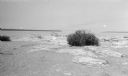
| Date: | 07 1923 |
|---|---|
| Description: | A grassy hummock stands out on the beach at Gravelly Island. |
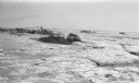
| Date: | 07 1923 |
|---|---|
| Description: | Members of the photographer's family shield their heads with their clothing while walking among grassy hummocks on Gravelly Island. There are many seagulls... |
| Date: | 07 1923 |
|---|---|
| Description: | View of Mackinac Island from a wooden pier. There are large houses, some with turrets, facing the water. |
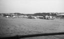
| Date: | 07 1923 |
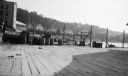
|---|---|
| Description: | View of Mackinac Island from a boat offshore. There are two large wooden piers with warehouses, and a beach on the right. Commercial buildings line the wat... |

| Date: | 1899 |
|---|---|
| Description: | A young Aldo Leopold posing proudly with his bamboo fishing pole, stringer of perch and a dog. The family was on vacation in the Cheneaux Islands, near Mac... |

| Date: | 1904 |
|---|---|
| Description: | Aldo Leopold standing in a boat with a group of young people. He is wearing pants, a shirt and a bow tie. Buildings can be seen on the shoreline in the bac... |

| Date: | 1904 |
|---|---|
| Description: | A young Aldo Leopold is posing smiling, wearing a jacket and bow tie while sitting on a pier. He is vacationing in the Cheneaux Islands. A shoreline with b... |

| Date: | 1836 |
|---|---|
| Description: | This map shows Havre Bay, a part of Maumee Bay, parts of Indian Island, Gard’s Island (Michigan), the Ottawa River, Vance River, creeks, and Ottawa Point (... |

| Date: | 1902 |
|---|---|
| Description: | This map shows shoals near Waugoshance Point. Lighthouses are labeled. Depths are shown by soundings and tints. Relief is shown by hachures. Inset includes... |

| Date: | 1906 |
|---|---|
| Description: | This map shows miles to other islands, harbors, canals, and passages. The South Fox ISL. LT and the Black Gas Buoy are colored in yellow and red. Depths ar... |

| Date: | 1893 |
|---|---|
| Description: | This map shows the depths of the East Neebish Rapids and the different types of minerals that make up the floor bed. Islands and Canada West is labeled. No... |

| Date: | 1925 |
|---|---|
| Description: | This map shows lakes, islands and bays. The Upper Peninsula of Michigan and Ontario are labeled. Three inset maps include the Upper end of St. Marys River ... |

| Date: | 08 1922 |
|---|---|
| Description: | View of Henry Rumsey's boat house, which is built of logs. An American flag is flying from the flagpole at the front of the boathouse. |
If you didn't find the material you searched for, our Library Reference Staff can help.
Call our reference desk at 608-264-6535 or email us at: