 Filter: Categories of Wisconsin Historical Images
Filter: State of Michigan
Filter: Subject of lakes
Filter: Categories of Wisconsin Historical Images
Filter: State of Michigan
Filter: Subject of lakes
| Date: | |
|---|---|
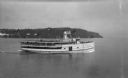
| Description: | View of the steamer ship "Islander" leaving Mackinac Island. Signs painted on the ship reads=: "Islander," "Arnold Line" and "St. Ignace Mackinac Island" (... |
| Date: | 1939 |
|---|---|
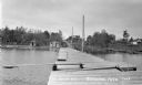
| Description: | View down long wooden dock. There is a diving board on the dock as well as ladders for people swimming. On shore are three parked automobiles and a few cab... |
| Date: | 1938 |
|---|---|
| Description: | View looking at people on the dock and diving tower on Lake Gogebic. Two boats are tied to the dock and buildings and trees are visible on the other side ... |

| Date: | 1935 |
|---|---|
| Description: | View of Lake Gogebic Park showing automobiles, trees, people around a picnic table, tents, a bench, dock and diving tower, as well as the lake and opposite... |
| Date: | 1934 |
|---|---|
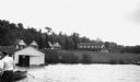
| Description: | View of the White House Resort on Lake Gogebic. A man stands on a dock on the far left, while a wooden rowboat and boathouse are also visible in the foregr... |

| Date: | 1933 |
|---|---|
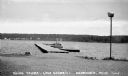
| Description: | View across water of three people sitting in a wooden rowboat on Lake Gogebic near Marenisco. In the background is the shoreline, as well as a large buildi... |

| Date: | 1904 |
|---|---|
| Description: | Aldo Leopold standing in a boat with a group of young people. He is wearing pants, a shirt and a bow tie. Buildings can be seen on the shoreline in the bac... |

| Date: | 1925 |
|---|---|
| Description: | This map shows lakes, islands and bays. The Upper Peninsula of Michigan and Ontario are labeled. Three inset maps include the Upper end of St. Marys River ... |

| Date: | 1851 |
|---|---|
| Description: | This map shows townships, villages, Indian villages, railroads, roads, mills, prairies, swamps, and canals. An inset map shows a plat of the copper distric... |

| Date: | 1864 |
|---|---|
| Description: | This map shows land owners, buildings, cities and villages, lakes, rivers, and roads. The margins include inset maps: Berlin; Mill Point; Holland; Ferrisvi... |

| Date: | 08 1922 |
|---|---|
| Description: | View of Henry Rumsey's boat house, which is built of logs. An American flag is flying from the flagpole at the front of the boathouse. |

| Date: | 08 1922 |
|---|---|
| Description: | Two young men are playing around on the water on two rafts. |

| Date: | 08 1922 |
|---|---|
| Description: | The person in midair, possibly David Rumsey, is diving from a height of 21 feet into Lake Michigamme. The log boathouse and American flag are in the foregr... |

| Date: | 08 23 1922 |
|---|---|
| Description: | Three women are striking a theatrical pose on the pier. They are probably members of the Holt, Rumsey, and/or Stroh families. The wooden flagpole is on the... |

| Date: | 08 23 1922 |
|---|---|
| Description: | A man and woman are striking a theatrical pose on the pier. Lake Michigamme is in the background. |
If you didn't find the material you searched for, our Library Reference Staff can help.
Call our reference desk at 608-264-6535 or email us at:
