 Filter: Categories of Wisconsin Historical Images
Filter: State of Michigan
Filter: Categories of Wisconsin Historical Images
Filter: State of Michigan

| Date: | 1900 |
|---|---|
| Description: | Large group of school boys and school girls with their teacher at the “old” Ontonagon Union School. |
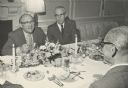
| Date: | 1970 |
|---|---|
| Description: | Wilbur Cohen and Arthur Altmeyer sit across the dinner table from John J. Corwin. All three men worked in U.S. Social Security Administration at different ... |

| Date: | 02 14 1913 |
|---|---|
| Description: | View of a campsite with two tents. One man is kneeling near a campfire blowing smoke over a tent and a line of clothes. Two other men are sitting nearby. |
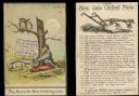
| Date: | 1878 |
|---|---|
| Description: | Front and back of advertising card for the New Gale Chilled Plow. On the front is a color illustration of a man sitting at the base of a tree pulling the t... |

| Date: | 1878 |
|---|---|
| Description: | Front of advertising card with a color illustration of a Gale Chilled Plow. |
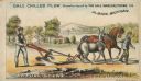
| Date: | 1878 |
|---|---|
| Description: | Front of advertising card featuring a color illustration of a man using a Gale Chilled Plow (Albion, Michigan) with a donkey in a field. Another man is wal... |
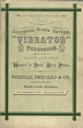
| Date: | 1871 |
|---|---|
| Description: | Front cover of catalog featuring "The Improved, Grain Saving 'Vibrator' Threshers." |
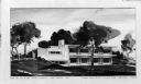
| Date: | |
|---|---|
| Description: | A rendering in the negative of a house for Mr. and Mrs. Donald Hayworth. |
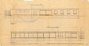
| Date: | |
|---|---|
| Description: | A rendering on tissue paper of a house design for Mr. and Mr.s Alexis J. Panshin. This is sheet #2, showing the south elevation. |
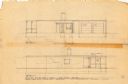
| Date: | |
|---|---|
| Description: | A rendering on tissue paper of a house design for Mr. and Mrs. Alexis J. Panshin. |
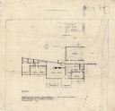
| Date: | 03 28 1947 |
|---|---|
| Description: | A rendering on tissue paper of the floor plan of a house for Mr. and Mrs. Alexis J. Panshin. |
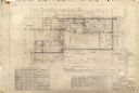
| Date: | 06 06 1949 |
|---|---|
| Description: | A rendering on tissue paper of the floor plan for the first floor of a house design for Mr. and Mrs. Donald Hayworth. |
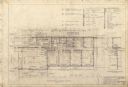
| Date: | 06 06 1949 |
|---|---|
| Description: | A rendering on tissue paper of the second story floor plan for a house design for Mr. and Mrs. Donald Hayworth. |

| Date: | 03 1955 |
|---|---|
| Description: | Silvercup Rocket at the 1955 Michigan State Fair. Original caption reads: "An estimated 100,000 visitors thronged through 'Silver Moon' on its initial disp... |

| Date: | 1836 |
|---|---|
| Description: | This map shows Havre Bay, a part of Maumee Bay, parts of Indian Island, Gard’s Island (Michigan), the Ottawa River, Vance River, creeks, and Ottawa Point (... |

| Date: | 1902 |
|---|---|
| Description: | This map shows shoals near Waugoshance Point. Lighthouses are labeled. Depths are shown by soundings and tints. Relief is shown by hachures. Inset includes... |

| Date: | 1906 |
|---|---|
| Description: | This map shows miles to other islands, harbors, canals, and passages. The South Fox ISL. LT and the Black Gas Buoy are colored in yellow and red. Depths ar... |

| Date: | 1858 |
|---|---|
| Description: | This map shows the depth of the West Channel and the different types of minerals that make up the floor bed. The steamboat range station is labeled. A note... |

| Date: | 1893 |
|---|---|
| Description: | This map shows the depths of the East Neebish Rapids and the different types of minerals that make up the floor bed. Islands and Canada West is labeled. No... |

| Date: | 1925 |
|---|---|
| Description: | This map shows lakes, islands and bays. The Upper Peninsula of Michigan and Ontario are labeled. Three inset maps include the Upper end of St. Marys River ... |
If you didn't find the material you searched for, our Library Reference Staff can help.
Call our reference desk at 608-264-6535 or email us at: