 Filter: Categories of Wisconsin Historical Images
Filter: State of Missouri
Filter: Type of Drawing
Filter: Categories of Wisconsin Historical Images
Filter: State of Missouri
Filter: Type of Drawing
| Date: | 05 02 1849 |
|---|---|
| Description: | The ferry landing in Weston, Missouri; Sketched by Wilkins on his 151-day journey from Missouri to California on the Overland Trail (also known as the Oreg... |
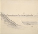
| Date: | 05 17 1849 |
|---|---|
| Description: | The ferry at Nodaway, Missouri; Sketched by Wilkins on his 151-day journey from Missouri to California on the Overland Trail (also known as the Oregon Trai... |
| Date: | 05 17 1849 |
|---|---|
| Description: | The Mill in Nodaway, Missouri; Sketched by Wilkins on his 151-day journey from Missouri to California on the Overland Trail (also known as the Oregon Trail... |
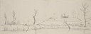
| Date: | 05 1849 |
|---|---|
| Description: | A farm in Missouri with one wagon visible. Sketched by Wilkins on his 151-day journey from Missouri to California on the Overland Trail (also known as the ... |
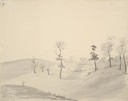
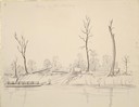
| Date: | 05 1849 |
|---|---|
| Description: | The vast prairies in Missouri; an oxen-pulled wagon is visible. Sketched by Wilkins on his 151-day journey from Missouri to California on the Overland Trai... |
| Date: | 05 1849 |
|---|---|
| Description: | Wilkins' wagon procession crossing a creek in Missouri; Sketched by Wilkins on his 151-day journey from Missouri to California on the Overland Trail (also ... |
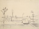
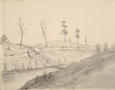
| Date: | 05 1849 |
|---|---|
| Description: | The bottom lands and a farm in Missouri; Sketched by Wilkins on his 151-day journey from Missouri to California on the Overland Trail (also known as the Or... |
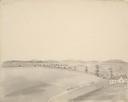
| Date: | 05 17 1849 |
|---|---|
| Description: | Nodaway, Missouri; Sketched by Wilkins on his 151-day journey from Missouri to California on the Overland Trail (also known as the Oregon Trail). Wilkins d... |
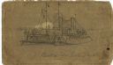
| Date: | |
|---|---|
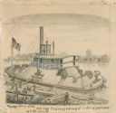
| Description: | "Ferry 'New Era' being transformed into a gunboat at St. Louis." Drawing includes workers building with lumber. |

| Date: | |
|---|---|
| Description: | "Building rafts, or pontoons, upon which to mount huge mortars — for use on the river. Scene at St. Louis." Men are building on a pontoon with lumber. Ther... |
| Date: | |
|---|---|
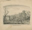
| Description: | "Conveying Provisions over the Ozark Mountains to the Army at Springfield, MO." Men on horseback are riding along a trail carrying supplies. |
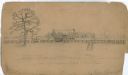
| Date: | |
|---|---|
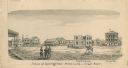
| Description: | "Plaza at Springfield — Missouri — Civil War". Image shows men standing in the Plaza and one man on horseback. Buildings include the Courthouse and a hospi... |
| Date: | 1861 |
|---|---|
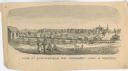
| Description: | "View of Springfield, MO. Frmonts [sic] Army in Possesion [sic]." Several people and a horse are in the foreground, and city buildings are in... |
| Date: | 04 1862 |
|---|---|
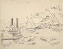
| Description: | Notes include: Sketch of Battle of Island #10. Sketch of Fort Pillow Tennessee. Gen. Pope had command of the land troops. |
| Date: | 1862 |
|---|---|
| Description: | The USS "Benton" was an "ironclad" ship which served as Capt. Andrew Hull Foote's flagship during the March 1862 assault on Island No. 10. |

| Date: | 1862 |
|---|---|
| Description: | An image from a sketchbook of "The Gunboats at No. 10 — Eve of Arrival before the I'sld". The drawing appears to be from the deck of a ship showing several... |
| Date: | |
|---|---|
| Description: | Home of Notorious Rebel — E.L. Newsome (located in New Madrid, Missouri). There is a farmstead with a man and woman in the foreground, a fence in the middl... |

| Date: | |
|---|---|
| Description: | Preliminary sketch for "Fort Pillow upon the Eve of the Evacuation by the Rebels". |

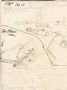
| Date: | 08 10 1862 |
|---|---|
| Description: | A hand-drawn map of the Battle of Wilson's Creek, Springfield, Missouri. Other notes and locations include: "Lyon was killed instantly while heading his tr... |

| Date: | |
|---|---|
| Description: | A hand-drawn map of the state of Missouri with a separate drawing of a map showing Forts Henry and Donelson. The Missouri map includes Jefferson City and s... |
If you didn't find the material you searched for, our Library Reference Staff can help.
Call our reference desk at 608-264-6535 or email us at: