 Filter: Categories of Wisconsin Historical Images
Filter: State of North Carolina
Filter: Subject of rivers
Filter: Categories of Wisconsin Historical Images
Filter: State of North Carolina
Filter: Subject of rivers
| Date: | |
|---|---|
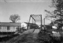
| Description: | View of Brown's Sawmill and bridge. A man stands in the center of the bridge, and industrial buildings are in the background. |

| Date: | 1865 |
|---|---|
| Description: | This map of the Bentonville, N.C., battlefield illustrates the positions of the Union and the Confederate troops, roads, rivers, vegetation, and the names ... |

| Date: | 1779 |
|---|---|
| Description: | Map of North Carolina showing counties, cities, towns, chapels, courthouses, Quaker meeting houses, forts, mountains, swamps, inlets, lakes, and rivers. A ... |

| Date: | 1795 |
|---|---|
| Description: | Map of North Carolina showing counties, cities, towns, courthouses, forts, roads, mountains, swamps, inlets, waterfalls, lakes, and rivers. A dotted square... |
If you didn't find the material you searched for, our Library Reference Staff can help.
Call our reference desk at 608-264-6535 or email us at:

