 Filter: Categories of Wisconsin Historical Images
Filter: State of North Carolina
Filter: Subject of roads
Filter: Categories of Wisconsin Historical Images
Filter: State of North Carolina
Filter: Subject of roads
| Date: | 1969 |
|---|---|
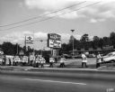
| Description: | View from across road of picket line of striking employees of the Neuhoff Company who were members of the Amalgamated Meat Packers and Butcher workmen unio... |

| Date: | 08 1957 |
|---|---|
| Description: | Women workers on strike against the Holly Farms Poultry Company, posed outside for a "solidarity" picture. Dorothy Johnson, wearing the third picket sign f... |
| Date: | |
|---|---|
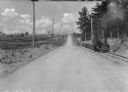
| Description: | View down center of a rural section of U.S. highway, with a small train running on railroad tracks alongside it. |
| Date: | |
|---|---|
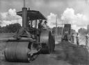
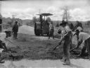
| Description: | View toward seven men resurfacing a section of Roxboro Road. There is a steam roller in the foreground. |
| Date: | |
|---|---|
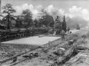
| Description: | A view of men grating the new surface of Roxboro Road, a section of the U.S. Highway. In the background is a steamroller. |
| Date: | |
|---|---|
| Description: | A view on men resurfacing rural sections of U.S. Highway, with machinery and a small train running alongside the road. |
| Date: | |
|---|---|
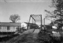
| Description: | View of Brown's Sawmill and bridge. A man stands in the center of the bridge, and industrial buildings are in the background. |

| Date: | 1865 |
|---|---|
| Description: | This map is a pen and ink tracing. Union positions are shown in blue and Confederate positions are shown in red. Roads, vegetation, and streams are labeled... |

| Date: | 1865 |
|---|---|
| Description: | This map of the Bentonville, N.C., battlefield illustrates the positions of the Union and the Confederate troops, roads, rivers, vegetation, and the names ... |

| Date: | 1865 |
|---|---|
| Description: | This map illustrates the lines of defense established by Confederate troops, under the command of General Joseph E. Johnston, at Raleigh, North Carolina, i... |

| Date: | 1795 |
|---|---|
| Description: | Map of North Carolina showing counties, cities, towns, courthouses, forts, roads, mountains, swamps, inlets, waterfalls, lakes, and rivers. A dotted square... |
If you didn't find the material you searched for, our Library Reference Staff can help.
Call our reference desk at 608-264-6535 or email us at:

