 Filter: Categories of Wisconsin Historical Images
Filter: State of North Carolina
Filter: Subject of water
Filter: Categories of Wisconsin Historical Images
Filter: State of North Carolina
Filter: Subject of water
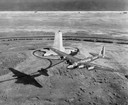
| Date: | 1939 |
|---|---|
| Description: | Aerial view of a B-15 flying over the granite memorial to the Wright Brothers' first flight at Kitty Hawk, North Carolina. The 60-foot memorial was dedicat... |
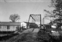
| Date: | |
|---|---|
| Description: | View of Brown's Sawmill and bridge. A man stands in the center of the bridge, and industrial buildings are in the background. |

| Date: | 1865 |
|---|---|
| Description: | This map is a pen and ink tracing. Union positions are shown in blue and Confederate positions are shown in red. Roads, vegetation, and streams are labeled... |

| Date: | 1865 |
|---|---|
| Description: | This map of the Bentonville, N.C., battlefield illustrates the positions of the Union and the Confederate troops, roads, rivers, vegetation, and the names ... |

| Date: | 1779 |
|---|---|
| Description: | Map of North Carolina showing counties, cities, towns, chapels, courthouses, Quaker meeting houses, forts, mountains, swamps, inlets, lakes, and rivers. A ... |

| Date: | 1795 |
|---|---|
| Description: | Map of North Carolina showing counties, cities, towns, courthouses, forts, roads, mountains, swamps, inlets, waterfalls, lakes, and rivers. A dotted square... |
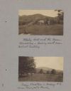
| Date: | 02 08 1921 |
|---|---|
| Description: | Page from booklet with a photograph at top with caption that reads: "Stanley Hall and the Green Mountains — looking north from School Building." There is a... |
If you didn't find the material you searched for, our Library Reference Staff can help.
Call our reference desk at 608-264-6535 or email us at:

