 Filter: Categories of Wisconsin Historical Images
Filter: State of South Carolina
Filter: Subject of cities and towns
Filter: Categories of Wisconsin Historical Images
Filter: State of South Carolina
Filter: Subject of cities and towns

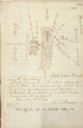
| Date: | 03 26 1876 |
|---|---|
| Description: | Hand-drawn map showing the place of Hook's defeat in York County in South Carolina. |
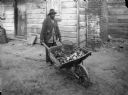
| Date: | |
|---|---|
| Description: | An African American vendor of oysters and clams is shown pushing his wheelbarrow. A building with an exterior brick chimney is behind him. |
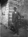
| Date: | |
|---|---|
| Description: | A man poses while selling chickens on the street. A building with an exterior brick chimney is behind him. |
| Date: | |
|---|---|
| Description: | Drawn map of Landsford, South Carolina, from Thomas Sumter Papers. |
| Date: | 1869 |
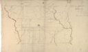
|---|---|
| Description: | Hand-drawn map of York County, South Carolina. |

| Date: | |
|---|---|
| Description: | A view of an ornate metal gateway to a city park. Trees, facing rows of park benches and a bust on a pedestal can be seen through the gate. |

| Date: | |
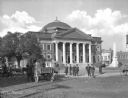
|---|---|
| Description: | A view of the side and front facade of the city hall. Three people and a dog are standing under the arch on the left. Caption reads: "Published by Norton D... |
| Date: | |
|---|---|
| Description: | A view of people standing on the sidewalk in front of the courthouse and the Confederate monument. |
| Date: | |
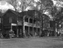
|---|---|
| Description: | View of the Beer Hotel. Guests stand outside of Horton's Pharmacy next door. Vehicles are parked along side the frontage road. |

| Date: | |
|---|---|
| Description: | A view of Washington Street. Trees line the street, as do telephone and/or electric lines. A carriage is parked on the right side of the street, in the mid... |
| Date: | |
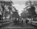
|---|---|
| Description: | A view of Magazine Street, with four people, two men and two women, posing on their horses. Trees line the street, and houses and fences are on both sides.... |

| Date: | |
|---|---|
| Description: | The Atlantic Coastline Railroad Station was formed on July 18, 1898 as a consolidation of the Wilmington, Columbia and Augusta Railroad and Northeastern Ra... |

| Date: | |
|---|---|
| Description: | View from street toward the exterior of the Farmers Bank and Trust Company. |
| Date: | |
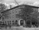
|---|---|
| Description: | View across intersection toward the Bank of Western Carolina, with people and automobiles on the street and sidewalks. |

| Date: | 1927 |
|---|---|
| Description: | The Beaufort river waterfront as seen from Lady's Island bridge. There are wooden buildings, piers and a tree-line in the background. |
| Date: | 10 01 1896 |
|---|---|
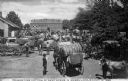
| Description: | A number of farmers bringing large bales of cotton to market on horse-drawn carts. A building in the back has the words "Bailey, Barksdale & Co." painted o... |

| Date: | |
|---|---|
| Description: | A view of the church from the side, as well as a view of the grounds, which includes a cemetery. An iron fence surrounds the grounds, with both carriage an... |
| Date: | 1865 |
|---|---|
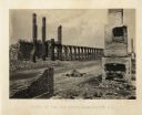
| Description: | The ruins of a railroad depot after General Sherman's men burned the town near the end of the Civil War. Plate 61 |
| Date: | 1865 |
|---|---|
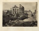
| Description: | The ruins of Charleston after General Sherman's men burned the town near the end of the Civil War. A man, smoking a pipe, and a boy sit on the shoreline of... |
| Date: | 1865 |
|---|---|
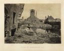
| Description: | Ruins of the Pinckney Mansion with rubble in the street after General Sherman's men burned the town near the end of the Civil War. Plate 59 |
If you didn't find the material you searched for, our Library Reference Staff can help.
Call our reference desk at 608-264-6535 or email us at: