 Filter: Categories of Wisconsin Historical Images
Filter: State of South Carolina
Filter: Subject of intellectual life
Filter: Categories of Wisconsin Historical Images
Filter: State of South Carolina
Filter: Subject of intellectual life

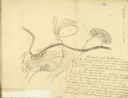
| Date: | 03 26 1876 |
|---|---|
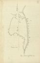
| Description: | Hand-drawn map showing the place of Hook's defeat in York County in South Carolina. |
| Date: | |
|---|---|
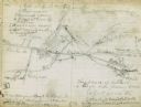
| Description: | Drawn map of the Catawba River, fishing creek, and surrounding landscape from the Sumter Papers. |
| Date: | |
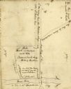
|---|---|
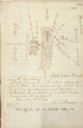
| Description: | Drawn map of Landsford, South Carolina, from Thomas Sumter Papers. |
| Date: | |
|---|---|
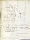
| Description: | Drawn map of the Hanging Rock Battlefield in the Thomas Sumter Papers. |
| Date: | |
|---|---|
| Description: | Drawn map of Hanging Rock Battlefield from the Thomas Sumter Papers. |
| Date: | |
|---|---|
| Description: | Drawn map of Blackstock's Plantation battlefield from the Sumter Papers. |
| Date: | |
|---|---|
| Description: | Drawn map of the Fish Damn Ford battlefield from the Thomas Sumter Papers. |
| Date: | |
|---|---|
| Description: | Drawn map of Blackstock's Plantation battlefield from the Thomas Sumter Papers. |
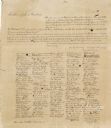
| Date: | 12 17 1860 |
|---|---|
| Description: | "An ordinance to dissolve the Union between the State of South Carolina and other states united with her under the compact entitled 'The Constitution of th... |

| Date: | 1918 |
|---|---|
| Description: | Two men and a woman sit and stand around a table inside the Ridgell Drug Company and ice cream parlor. Several display cases are arranged behind them and t... |

| Date: | 1780 |
|---|---|
| Description: | This map shows the townships, parishes, cities, towns, plantations, lakes, rivers, swamps, and roads near the coast of South Carolina and Georgia. Emphasis... |
If you didn't find the material you searched for, our Library Reference Staff can help.
Call our reference desk at 608-264-6535 or email us at: