 Filter: Categories of Wisconsin Historical Images
Filter: State of South Carolina
Filter: Subject of islands
Filter: Categories of Wisconsin Historical Images
Filter: State of South Carolina
Filter: Subject of islands
| Date: | |
|---|---|
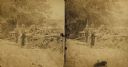
| Description: | Stereograph of a mock battery erected by the 79h New York Volunteer Artillery at Seabrook Point, Coosaw River. |
| Date: | |
|---|---|
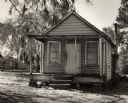
| Description: | Building housing the Wadmalaw Island Citizenship Group. |
| Date: | |
|---|---|
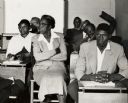
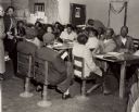
| Description: | Wadmalaw Island Citizenship group participants in the midst of a session. |
| Date: | |
|---|---|
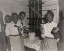
| Description: | Wadmalaw Island Citizenship group coffee break. Third from the left is Bernice Robinson, a teacher in the first school, former Highlander Folk School stud... |
| Date: | |
|---|---|
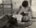
| Description: | Two children waiting for their parents at the Wadmalaw Citizenship School. |
| Date: | |
|---|---|
| Description: | Mrs. Brewer teaching a citizenship class at Edisto Island. Septima Clark, far left. |
| Date: | |
|---|---|
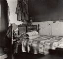
| Description: | A bedroom on one of the South Carolina islands which hosted the Citizenship group. |

| Date: | |
|---|---|
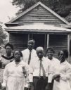
| Description: | Family on Sea Island that was part of the Citizenship group that took place on the island. |
| Date: | |
|---|---|
| Description: | A group participating in the Citizenship group standing in front of Morning Star Hall, Johns Island. Charleston Evening Post and New Courier image. |

| Date: | |
|---|---|
| Description: | A child holding a baby next to a television on Johns Island. Part of the Citizenship group that convened there. |
| Date: | |
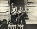
|---|---|
| Description: | An African American woman with two children on the porch of a house on Johns Island. |

| Date: | |
|---|---|
| Description: | A group of African American boys wearing hats on Johns Island. |

| Date: | 1865 |
|---|---|
| Description: | Exterior of Fort Sumpter [sic]. There are several men and a boat on the shoreline in the foreground. Plate 56 |

| Date: | |
|---|---|
| Description: | Stereograph of a mock battery erected by the 79h New York Volunteer Artillery at Seabrook Point, Coosaw River. |

| Date: | 1780 |
|---|---|
| Description: | This map shows the townships, parishes, cities, towns, plantations, lakes, rivers, swamps, and roads near the coast of South Carolina and Georgia. Emphasis... |

| Date: | 1779 |
|---|---|
| Description: | Map of South Carolina showing boundary lines, Native American land, precincts, townships, cities, towns, forts, roads, mountains, hills, swamps, islands, a... |

| Date: | 1795 |
|---|---|
| Description: | Map of South Carolina showing the precincts, cities, towns, Native American villages (marked with a triangle), courthouses, roads, mountains, swamps, islan... |
If you didn't find the material you searched for, our Library Reference Staff can help.
Call our reference desk at 608-264-6535 or email us at: