 Filter: Categories of Wisconsin Historical Images
Filter: State of South Carolina
Filter: Subject of rivers
Filter: Categories of Wisconsin Historical Images
Filter: State of South Carolina
Filter: Subject of rivers
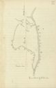
| Date: | |
|---|---|
| Description: | Drawn map of the Catawba River, fishing creek, and surrounding landscape from the Sumter Papers. |
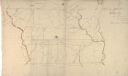
| Date: | 1869 |
|---|---|
| Description: | Hand-drawn map of York County, South Carolina. |

| Date: | |
|---|---|
| Description: | View toward people standing on large rocks in a river. The people are dispersed across the wide river and the river is lined by trees. |
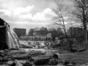
| Date: | |
|---|---|
| Description: | View of a mill dam and falls on the Saluda River with buildings in the background. |

| Date: | 1927 |
|---|---|
| Description: | The Beaufort river waterfront as seen from Lady's Island bridge. There are wooden buildings, piers and a tree-line in the background. |

| Date: | |
|---|---|
| Description: | Logging scene on Waccamaw River. On the right is a group of logs floating in a contained area in front of a boat. In the background on the left is another... |

| Date: | 1780 |
|---|---|
| Description: | This map shows the townships, parishes, cities, towns, plantations, lakes, rivers, swamps, and roads near the coast of South Carolina and Georgia. Emphasis... |

| Date: | 1779 |
|---|---|
| Description: | Map of South Carolina showing boundary lines, Native American land, precincts, townships, cities, towns, forts, roads, mountains, hills, swamps, islands, a... |

| Date: | 1795 |
|---|---|
| Description: | Map of South Carolina showing the precincts, cities, towns, Native American villages (marked with a triangle), courthouses, roads, mountains, swamps, islan... |
If you didn't find the material you searched for, our Library Reference Staff can help.
Call our reference desk at 608-264-6535 or email us at: