Filter: Categories of Wisconsin Historical Images
Filter: State of South Carolina
Filter: Subject of roads
Filter: Categories of Wisconsin Historical Images
Filter: State of South Carolina
Filter: Subject of roads
| Date: | |
|---|---|
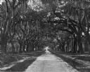
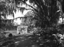
| Description: | A view looking down a dirt road leading to what appears to be a house. The road is bordered by large oak trees with Spanish moss hanging from their limbs. |
| Date: | |
|---|---|
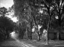
| Description: | A view of Old Dorchester Road, a small dirt, country road with a small wooden structure or house one one side, and lined with trees and telephone poles on ... |
| Date: | |
|---|---|
| Description: | A view of 'Secession Hill', where the first secession meeting was held in November of 1860. Caption reads: "'Secession Hill' Abbeville, S.C." |

| Date: | |
|---|---|
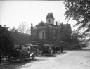
| Description: | South Main Street and City Hall. On the left side of the street, a business sign reads: "The Daily Mail." Caption reads: "South Main Street and City Hall, ... |
| Date: | |
|---|---|
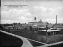
| Description: | Elevated view of the mills' sprawling building complex. Caption reads: "Middleburg Cotton Mills, Batesburg, S.C." |
| Date: | |
|---|---|
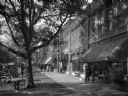
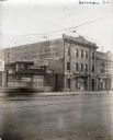
| Description: | Street scene featuring Frierson's Pharmacy in the center. People walk the sidewalks and cars are parked in front of the row of stores. |
| Date: | |
|---|---|
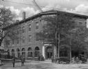
| Description: | View of the Beer Hotel. Guests stand outside of Horton's Pharmacy next door. Vehicles are parked along side the frontage road. |
| Date: | |
|---|---|
| Description: | View of a brick cottage with ivy in a clearing as seen from a small dirt road through the woods. The road is bordered by flowering azalea bushes and the Sp... |

| Date: | |
|---|---|
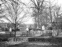
| Description: | A view of Washington Street. Trees line the street, as do telephone and/or electric lines. A carriage is parked on the right side of the street, in the mid... |

| Date: | |
|---|---|
| Description: | The Atlantic Coastline Railroad Station was formed on July 18, 1898 as a consolidation of the Wilmington, Columbia and Augusta Railroad and Northeastern Ra... |
| Date: | |
|---|---|
| Description: | View across intersection toward the Bank of Western Carolina, with people and automobiles on the street and sidewalks. |
| Date: | |
|---|---|
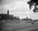
| Description: | A view of a military drill on the campus of Clemson College, which opened in 1893. College buildings stand in the background, and lines of soldiers march i... |

| Date: | |
|---|---|
| Description: | A view of the church from the side, as well as a view of the grounds, which includes a cemetery. An iron fence surrounds the grounds, with both carriage an... |
| Date: | |
|---|---|
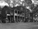
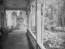
| Description: | People sit in rocking chairs on the porch of the Pine Forest Inn. Flowering bushes and shrubs surround the porch and an automobile is driving along the roa... |
| Date: | 1925 |
|---|---|
| Description: | Exterior view of the International Harvester Company Columbia branch building. Brick buildings stand on either side; to the left is a building bearing the ... |

| Date: | 1780 |
|---|---|
| Description: | This map shows the townships, parishes, cities, towns, plantations, lakes, rivers, swamps, and roads near the coast of South Carolina and Georgia. Emphasis... |

| Date: | 1779 |
|---|---|
| Description: | Map of South Carolina showing boundary lines, Native American land, precincts, townships, cities, towns, forts, roads, mountains, hills, swamps, islands, a... |

| Date: | 1795 |
|---|---|
| Description: | Map of South Carolina showing the precincts, cities, towns, Native American villages (marked with a triangle), courthouses, roads, mountains, swamps, islan... |
If you didn't find the material you searched for, our Library Reference Staff can help.
Call our reference desk at 608-264-6535 or email us at: