 Filter: Categories of Wisconsin Historical Images
Filter: State of Tennessee
Filter: Year of 1800-1899
Filter: Subject of land
Filter: Categories of Wisconsin Historical Images
Filter: State of Tennessee
Filter: Year of 1800-1899
Filter: Subject of land
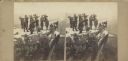
| Date: | 1864 |
|---|---|
| Description: | Albumen stereograph of the Union Army brass band posed and playing atop Lookout Point. The Tennessee River is in the background. |
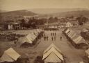
| Date: | 1864 |
|---|---|
| Description: | Elevated view of Battery C, 1st Regiment, Wisconsin Heavy Artillery at Fort Sherman, shown here after the battles of Missionary Ridge and Lookout Mountain.... |
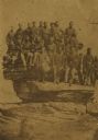
| Date: | 04 20 1864 |
|---|---|
| Description: | Company D, Twenty-first Wisconsin Volunteer Infantry. Top row (left to right): John Buboltz, Spencer Orlup, J. Henry Otto, Lyman C. Wait, Andrew Jackson, W... |
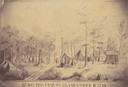
| Date: | 1862 |
|---|---|
| Description: | Sketch of the camp of the 15th Regiment of the Wisconsin Volunteer Infantry on Island No. 10 during the Civil War. Colonel Hans Christian Heg commanded the... |
| Date: | 1863 |
|---|---|
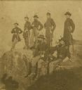
| Description: | Union army officers. From left are: General U.S. Grant, General Rawlins, General Webster, Colonel Lagow, and Colonel Killyer take a break. |
| Date: | 1863 |
|---|---|
| Description: | The Twenty-First Wisconsin Volunteer Infantry posing on Lookout Mountain. From right to left: Fred W. Borcherdt of Manitowoc, Wisconsin; acting Adjutant Co... |
| Date: | 06 1862 |
|---|---|
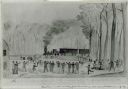
| Description: | First train crossing the Obion River, Tennessee, on the Ohio and Mobile Railroad on a bridge built by the 12th Wisconsin Volunteers. Watercolor by John Ga... |

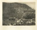
| Date: | 1864 |
|---|---|
| Description: | View across the Tennessee River toward the city and Cameron Hill, showing the military bridge and some Union Army installations put up following the occupa... |
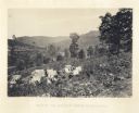
| Date: | 1866 |
|---|---|
| Description: | Cliffs along Lu-la Lake. A waterfall is in the background. Plate 15 |
| Date: | 1866 |
|---|---|
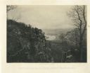
| Description: | Elevated view of the Chattanooga Valley, with a river in the far background. A cliff face and trees are in the foreground. Plate 14 |
| Date: | 1866 |
|---|---|
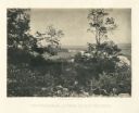
| Description: | View of the Chattanooga Valley and a river from Lookout Mountain. Trees are in the foreground, and a city is in the background across the river. Plate 1... |
| Date: | 1866 |
|---|---|
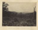
| Description: | Location of Sherman's attack at Chattanooga. There is a road, trees and shrubs in the foreground, overlooking a valley. Mountains are in the distance. P... |
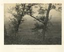
| Date: | 1866 |
|---|---|
| Description: | A road runs up the side of Mission Ridge with several trees. Trees and shrubs are in the foreground, overlooking a valley. Mountains are in the distance. |
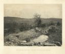
| Date: | 1866 |
|---|---|
| Description: | View from Mission Ridge of the valley floor where fighting took place. Plate 10 |
| Date: | 1866 |
|---|---|
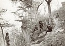
| Description: | A rocky ridge with bushes and scrub atop Mission Ridge is in the foreground. Orchard Knob is in the distance. The valley where the fighting took place is i... |
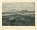
| Date: | 1866 |
|---|---|
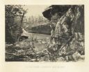
| Description: | Two log buildings are in the foreground. A bridge spans a river in the middle distance, and the city of Chattanooga is on the far side at the base of a mou... |
| Date: | 1864 |
|---|---|
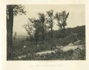
| Description: | View down hillside of Union soldiers standing in front of a group of tents. There is a valley and mountains in the distance. Plate 07 |
| Date: | 1864 |
|---|---|
| Description: | Union soldiers stand by their tents in front of a trestle bridge on the railroad line that spans a valley. A mountain is in the background. Plate 06 |

| Date: | 1864 |
|---|---|
| Description: | View down to valley of Union soldiers posing on the roof of a log building. A log bridge crosses a stream, and many trees are on the hillsides. Plate 05... |

| Date: | 1862 |
|---|---|
| Description: | This map of the Battle of Shiloh shows relief by hachures, vegetation, drainage, houses, fields, fences, mills, and roads and is color coded to show the mo... |
If you didn't find the material you searched for, our Library Reference Staff can help.
Call our reference desk at 608-264-6535 or email us at: