 Filter: Categories of Wisconsin Historical Images
Filter: State of Tennessee
Filter: Year of 1800-1899
Filter: Subject of transportation
Filter: Categories of Wisconsin Historical Images
Filter: State of Tennessee
Filter: Year of 1800-1899
Filter: Subject of transportation
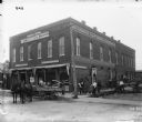
| Date: | 1899 |
|---|---|
| Description: | View from street of workers, including some African Americans, loading (and/or unloading) agricultural equipment and parts outside a general office of the ... |
| Date: | 02 15 1862 |
|---|---|
| Description: | "The 2nd and 7th Iowa and the 52nd Indiana headed by General Smith storming up the rebel works at Fort Donelson causing its surrender to General Grant the ... |
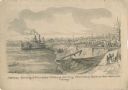
| Date: | 06 06 1862 |
|---|---|
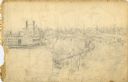
| Description: | "Colonel Ellet's Rams approaching the city of Memphis, Tennessee, to demand its surrender." Sketch of a cityscape in the background, the river with numero... |
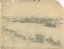
| Date: | 05 1862 |
|---|---|
| Description: | "Hamburg Landing, 4 miles below Pittsburg Landing, Commisary [sic] Depot of Gen. Hallek's Army." An encampment with soldiers along the river with a ... |
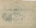
| Date: | 1862 |
|---|---|
| Description: | This is the preliminary sketch for "Hamburg Landing, 4 miles below Pittsburg Landing, Commisary [sic] Depot of Gen. Hallek's Army." Shows an encampm... |
| Date: | 06 1862 |
|---|---|
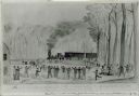
| Description: | First train crossing the Obion River, Tennessee, on the Ohio and Mobile Railroad on a bridge built by the 12th Wisconsin Volunteers. Watercolor by John Ga... |
| Date: | 1864 |
|---|---|
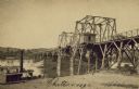
| Description: | Carte-de-visite of a bridge at Chattanooga with a steamship passing nearby. |

| Date: | 1864 |
|---|---|
| Description: | View across the Tennessee River toward the city and Cameron Hill, showing the military bridge and some Union Army installations put up following the occupa... |
| Date: | 1864 |
|---|---|
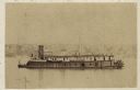
| Description: | Union gunboat "Prairie Bird," a small rear-wheel steamship. |
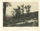
| Date: | 1866 |
|---|---|
| Description: | A road runs up the side of Mission Ridge with several trees. Trees and shrubs are in the foreground, overlooking a valley. Mountains are in the distance. |
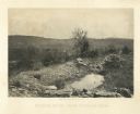
| Date: | 1866 |
|---|---|
| Description: | A rocky ridge with bushes and scrub atop Mission Ridge is in the foreground. Orchard Knob is in the distance. The valley where the fighting took place is i... |
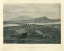
| Date: | 1866 |
|---|---|
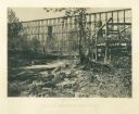
| Description: | Two log buildings are in the foreground. A bridge spans a river in the middle distance, and the city of Chattanooga is on the far side at the base of a mou... |
| Date: | 1864 |
|---|---|
| Description: | Union soldiers stand by their tents in front of a trestle bridge on the railroad line that spans a valley. A mountain is in the background. Plate 06 |

| Date: | 1864 |
|---|---|
| Description: | View down to valley of Union soldiers posing on the roof of a log building. A log bridge crosses a stream, and many trees are on the hillsides. Plate 05... |
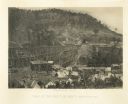
| Date: | 1864 |
|---|---|
| Description: | View from shoreline of tall trestle bridge on the railroad line crossing the river at Whiteside. Two men sit on logs in the river on the left. More men sit... |
| Date: | 1864 |
|---|---|
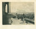
| Description: | View down capitol building steps, where cannons sit on a landing, and statues decorate two lampposts. The city spreads out far below. Plate 03 |

| Date: | 1862 |
|---|---|
| Description: | This map of the Battle of Shiloh shows relief by hachures, vegetation, drainage, houses, fields, fences, mills, and roads and is color coded to show the mo... |

| Date: | 1863 |
|---|---|
| Description: | This map is a hand-colored, pen and ink, drawing by Ole R. Dahl of Co. B, 15 Wisconsin Infantry shows the battlefield at Stones River, depicting roads, str... |

| Date: | 1863 |
|---|---|
| Description: | This colored map of the Battle of Chattanooga depicts the positions of the Union and Confederate troops before the battle and on each day of the battle. Al... |

| Date: | 1863 |
|---|---|
| Description: | This map of the Battle of Chattanooga depicts roads, railroads, drainage, vegetation, relief, and the names of residents in the outlying areas. Fourteen Wi... |
If you didn't find the material you searched for, our Library Reference Staff can help.
Call our reference desk at 608-264-6535 or email us at: