 Filter: Categories of Wisconsin Historical Images
Filter: State of Virginia
Filter: Subject of arts
Filter: Categories of Wisconsin Historical Images
Filter: State of Virginia
Filter: Subject of arts
| Date: | |
|---|---|
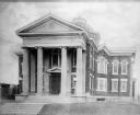
| Description: | View of the front of the church, which has a columned porch, topped by a pediment. The windows have a variety of shapes, but all contain stained glass and ... |

| Date: | |
|---|---|
| Description: | An elevated view of the interior, overlooking the seating area, with the altar at the right. The pulpit, clergy seating, and baptismal font are bordered by... |
| Date: | |
|---|---|
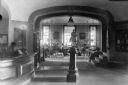
| Description: | Interior of a small reading room at Collis P. Huntington Memorial Library, built in 1903. A woman sits at a reference desk on the left, and other people re... |

| Date: | 1880 |
|---|---|
| Description: | Interior view of Washington and Lee University chapel showing tomb of Robert E. Lee. Portraits hang on the wall around an arch leading to the tomb. |
| Date: | 1907 |
|---|---|
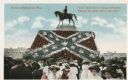
| Description: | Colored postcard view of crowd in front of the stand. Caption reads: "Human Confederate Flag." Text at top right reads: "And 'twill live in song and story.... |

| Date: | |
|---|---|
| Description: | A monument and statue honoring the Confederate general Thomas Jonathan "Stonewall" Jackson. There is a cemetery in the background on the left. |
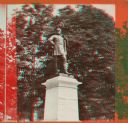
| Date: | 1870 |
|---|---|
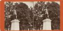
| Description: | A stereograph of a statue of Thomas J. "Stonewall" Jackson. |
| Date: | 1870 |
|---|---|
| Description: | A stereograph of a statue of Thomas J. "Stonewall" Jackson. |

| Date: | |
|---|---|
| Description: | Portrait of General Robert E. Lee (1807-1870). The original photograph taken in 1865 is located at Washington and Lee University. |
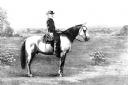
| Date: | |
|---|---|
| Description: | Copy of a painting of General Robert E. Lee (1807-1870) on his horse, Traveller. The original painting was found in Stratford Hall, the ancestral home of ... |
| Date: | |
|---|---|
| Description: | Bronze statue of Hugh Mercer (1726-1777), Physician and Brigadier General of the Continental Army during the Revolutionary War. Mercer died of wound he rec... |
| Date: | 1907 |
|---|---|
| Description: | View of the statue, "Indian Buffalo Hunt," by Henry Bush-Brown. The sculpture was exhibited at the Jamestown Exposition. |

| Date: | |
|---|---|
| Description: | Interior view of Mount Vernon, built in 1757 by George Washington. Curtis' Music Room houses a harpsichord, as well as other instruments. |
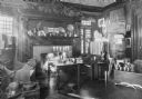
| Date: | |
|---|---|
| Description: | Interior view of an early American home. The room features an elaborate fireplace, a violin, and paintings. |

| Date: | 04 07 2011 |
|---|---|
| Description: | An on-set portrait of PBS NewsHour co-anchor Jim Lehrer. |

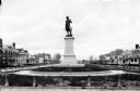
| Date: | |
|---|---|
| Description: | View of the Henry Clay Monument with a statue of Clay inside. In front stand two young girls wearing dresses. Each girl is holding a pet rabbit. On the rig... |

| Date: | 1770 |
|---|---|
| Description: | The south west sheet of a four sheet map of Virginia, showing the counties, mountains, rivers, court houses, a few cities, and mills. A few Plantations ar... |

| Date: | 1671 |
|---|---|
| Description: | Map of Virginia depicting the discoveries detailed by John Smith in his exploration of the region. It shows Jamestown, Native American tribes and villages,... |

| Date: | 1755 |
|---|---|
| Description: | Map of Virginia and parts of Maryland, North Carolina, and New Jersey. It shows borders, boundary lines, some Native American land, counties, cities, towns... |

| Date: | 1762 |
|---|---|
| Description: | Map of Virginia and parts of Maryland. It shows borders, boundary lines, Native American tribes and land, towns, forts, roads, mountains, waterfalls, bays,... |
If you didn't find the material you searched for, our Library Reference Staff can help.
Call our reference desk at 608-264-6535 or email us at: