 Filter: Categories of Wisconsin Historical Images
Filter: State of Virginia
Filter: Subject of clothing and dress
Filter: Subject of water
Filter: Categories of Wisconsin Historical Images
Filter: State of Virginia
Filter: Subject of clothing and dress
Filter: Subject of water
| Date: | 1922 |
|---|---|
| Description: | Harold F. McCormick (with cup) and his children, left to right: Muriel, Harold, Jr. and Mathilde at the Walnut Grove farm in Rockbridge County. |

| Date: | 02 21 1874 |
|---|---|
| Description: | African American boatmen run a rapids in a small river boat. |

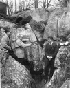
| Date: | |
|---|---|
| Description: | A man kneels by large spring surrounded by split-rail fencing. |
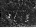
| Date: | |
|---|---|
| Description: | A couple walking down the rustic stairway at Caldeno Falls. Caption reads: "Caldeno Falls, Delaware Water Gap, PA." |

| Date: | |
|---|---|
| Description: | William Howard Taft (S9/15/1857 – 3/8/1930), the 27th President of the United States (3/4/1909 – 3/4/1913), wearing a top hat and sitting in a boat with a ... |
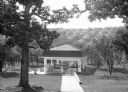
| Date: | |
|---|---|
| Description: | View looking down into a covered shelter, built in the early 1900's, for Massanetta Springs. A group of people are sitting in the shelter which is in a cou... |

| Date: | 1957 |
|---|---|
| Description: | Ceremony beneath the guns on board the U.S.S. Wisconsin. A number of spectators and sailors are seated in the foreground, and uniformed sailors line... |

| Date: | 11 1957 |
|---|---|
| Description: | Uniformed sailors gathered on the deck of the U.S.S. Wisconsin during decommissioning ceremonies. |

| Date: | 1950 |
|---|---|
| Description: | Front view of George Washington's Mount Vernon from the circular driveway. A line of people are waiting at the entrance. The cupola on the roof has a weath... |

| Date: | 1671 |
|---|---|
| Description: | Map of Virginia depicting the discoveries detailed by John Smith in his exploration of the region. It shows Jamestown, Native American tribes and villages,... |

| Date: | 1755 |
|---|---|
| Description: | Map of Virginia and parts of Maryland, North Carolina, and New Jersey. It shows borders, boundary lines, some Native American land, counties, cities, towns... |

| Date: | 02 15 1938 |
|---|---|
| Description: | Two men are standing on the stone wall, and another man is standing on scaffolding inside the dam. In the foreground are large stones, logs, and water. Han... |

| Date: | 02 15 1938 |
|---|---|
| Description: | A group of men are working on the dam. Handwritten on back: "Outside of Dam wall at center." |
If you didn't find the material you searched for, our Library Reference Staff can help.
Call our reference desk at 608-264-6535 or email us at:
